You are here: Home > Network List > 1U - Mt. Paektu Seismic Network Stations List
> Station PDBD Paektu Bridge > Earthquake Result Viewer
PDBD Paektu Bridge - Earthquake Result Viewer
| Earthquake location: |
Southeast Of Loyalty Islands |
| Earthquake latitude/longitude: |
-22.8/171.4 |
| Earthquake time(UTC): |
2014/11/10 (314) 10:04:21 GMT |
| Earthquake Depth: |
10 km |
| Earthquake Magnitude: |
6.1 MWP |
| Earthquake Catalog/Contributor: |
NEIC PDE/NEIC COMCAT |
|
| Network: |
1U Mt. Paektu Seismic Network |
| Station: |
PDBD Paektu Bridge |
| Lat/Lon: |
41.99 N/128.13 E |
| Elevation: |
2164 m |
|
| Distance: |
75.9 deg |
| Az: |
328.168 deg |
| Baz: |
139.235 deg |
| Ray Param: |
0.051375527 |
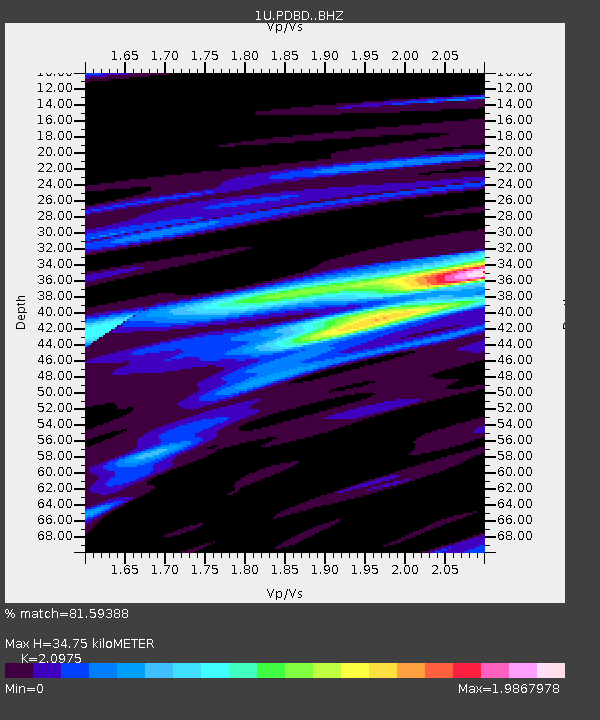
| Estimated Moho Depth: |
34.75 km |
| Estimated Crust Vp/Vs: |
2.10 |
| Assumed Crust Vp: |
6.472 km/s |
| Estimated Crust Vs: |
3.086 km/s |
| Estimated Crust Poisson's Ratio: |
0.35 |
|
| Radial Match: |
81.59388 % |
| Radial Bump: |
400 |
| Transverse Match: |
70.7421 % |
| Transverse Bump: |
400 |
| SOD ConfigId: |
3390531 |
| Insert Time: |
2019-04-14 22:13:31.784 +0000 |
| GWidth: |
2.5 |
| Max Bumps: |
400 |
| Tol: |
0.001 |
|

Signal To Noise
| Channel | StoN | STA | LTA |
| 1U:PDBD: :BHZ:20141110T10:15:36.860015Z | 5.872373 | 6.524915E-7 | 1.1111206E-7 |
| 1U:PDBD: :BHN:20141110T10:15:36.860015Z | 2.9593723 | 2.844399E-7 | 9.611493E-8 |
| 1U:PDBD: :BHE:20141110T10:15:36.860015Z | 2.776008 | 3.0719906E-7 | 1.1066217E-7 |
| Arrivals |
| Ps | 6.1 SECOND |
| PpPs | 16 SECOND |
| PsPs/PpSs | 22 SECOND |


