You are here: Home > Network List > TA - USArray Transportable Network (new EarthScope stations) Stations List
> Station I49A Point Hope, MI, USA > Earthquake Result Viewer
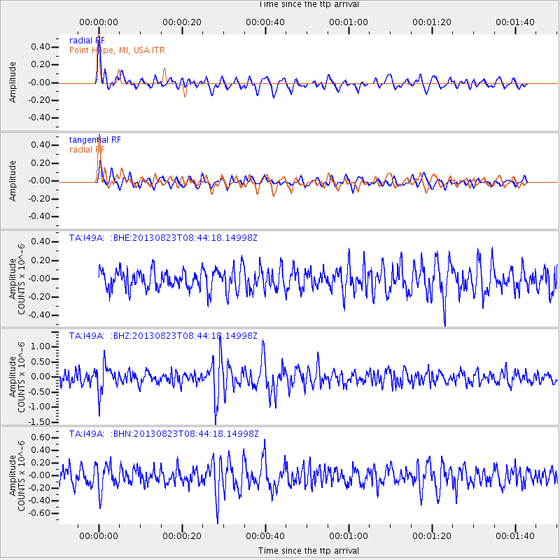
I49A Point Hope, MI, USA - Earthquake Result Viewer
*The percent match for this event was below the threshold and hence no stack was calculated.
| Earthquake location: |
Northern Chile |
| Earthquake latitude/longitude: |
-22.3/-68.6 |
| Earthquake time(UTC): |
2013/08/23 (235) 08:34:06 GMT |
| Earthquake Depth: |
111 km |
| Earthquake Magnitude: |
5.8 MWW, 5.7 MWD, 5.8 MWW, 5.8 MWB, 5.8 MWC |
| Earthquake Catalog/Contributor: |
NEIC PDE/NEIC COMCAT |
|
| Network: |
TA USArray Transportable Network (new EarthScope stations) |
| Station: |
I49A Point Hope, MI, USA |
| Lat/Lon: |
43.94 N/82.82 W |
| Elevation: |
217 m |
|
| Distance: |
67.2 deg |
| Az: |
348.89 deg |
| Baz: |
165.695 deg |
| Ray Param: |
$rayparam |
*The percent match for this event was below the threshold and hence was not used in the summary stack. |
|
| Radial Match: |
69.21006 % |
| Radial Bump: |
400 |
| Transverse Match: |
59.334084 % |
| Transverse Bump: |
400 |
| SOD ConfigId: |
626651 |
| Insert Time: |
2014-04-18 02:45:39.279 +0000 |
| GWidth: |
2.5 |
| Max Bumps: |
400 |
| Tol: |
0.001 |
|
Signal To Noise
| Channel | StoN | STA | LTA |
| TA:I49A: :BHZ:20130823T08:44:18.14998Z | 2.9730792 | 4.2772362E-7 | 1.4386552E-7 |
| TA:I49A: :BHN:20130823T08:44:18.14998Z | 1.9674456 | 2.1080196E-7 | 1.07145E-7 |
| TA:I49A: :BHE:20130823T08:44:18.14998Z | 1.5377648 | 1.3959807E-7 | 9.0779864E-8 |
| Arrivals |
| Ps | |
| PpPs | |
| PsPs/PpSs | |


