You are here: Home > Network List > YT07 - POLENET Stations List
> Station FISH FISH > Earthquake Result Viewer
FISH FISH - Earthquake Result Viewer
| Earthquake location: |
Southeast Of Loyalty Islands |
| Earthquake latitude/longitude: |
-22.8/171.4 |
| Earthquake time(UTC): |
2014/11/10 (314) 10:04:21 GMT |
| Earthquake Depth: |
10 km |
| Earthquake Magnitude: |
6.1 MWP |
| Earthquake Catalog/Contributor: |
NEIC PDE/NEIC COMCAT |
|
| Network: |
YT POLENET |
| Station: |
FISH FISH |
| Lat/Lon: |
78.93 S/162.57 E |
| Elevation: |
273 m |
|
| Distance: |
56.4 deg |
| Az: |
182.054 deg |
| Baz: |
9.853 deg |
| Ray Param: |
0.06418981 |
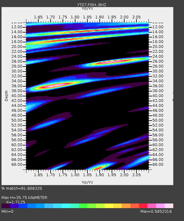
| Estimated Moho Depth: |
35.75 km |
| Estimated Crust Vp/Vs: |
1.71 |
| Assumed Crust Vp: |
6.43 km/s |
| Estimated Crust Vs: |
3.755 km/s |
| Estimated Crust Poisson's Ratio: |
0.24 |
|
| Radial Match: |
91.686325 % |
| Radial Bump: |
400 |
| Transverse Match: |
76.68363 % |
| Transverse Bump: |
400 |
| SOD ConfigId: |
3390531 |
| Insert Time: |
2019-04-14 22:18:20.563 +0000 |
| GWidth: |
2.5 |
| Max Bumps: |
400 |
| Tol: |
0.001 |
|

Signal To Noise
| Channel | StoN | STA | LTA |
| YT:FISH: :BHZ:20141110T10:13:31.373992Z | 11.461143 | 1.0430862E-6 | 9.101066E-8 |
| YT:FISH: :BHN:20141110T10:13:31.373992Z | 4.477738 | 4.090883E-7 | 9.136048E-8 |
| YT:FISH: :BHE:20141110T10:13:31.373992Z | 1.3759176 | 1.5288747E-7 | 1.1111674E-7 |
| Arrivals |
| Ps | 4.2 SECOND |
| PpPs | 14 SECOND |
| PsPs/PpSs | 18 SECOND |


