You are here: Home > Network List > YT07 - POLENET Stations List
> Station LONW LONW > Earthquake Result Viewer
LONW LONW - Earthquake Result Viewer
| Earthquake location: |
Southeast Of Loyalty Islands |
| Earthquake latitude/longitude: |
-22.8/171.4 |
| Earthquake time(UTC): |
2014/11/10 (314) 10:04:21 GMT |
| Earthquake Depth: |
10 km |
| Earthquake Magnitude: |
6.1 MWP |
| Earthquake Catalog/Contributor: |
NEIC PDE/NEIC COMCAT |
|
| Network: |
YT POLENET |
| Station: |
LONW LONW |
| Lat/Lon: |
81.35 S/152.74 E |
| Elevation: |
1548 m |
|
| Distance: |
59.1 deg |
| Az: |
183.244 deg |
| Baz: |
20.174 deg |
| Ray Param: |
0.062381715 |
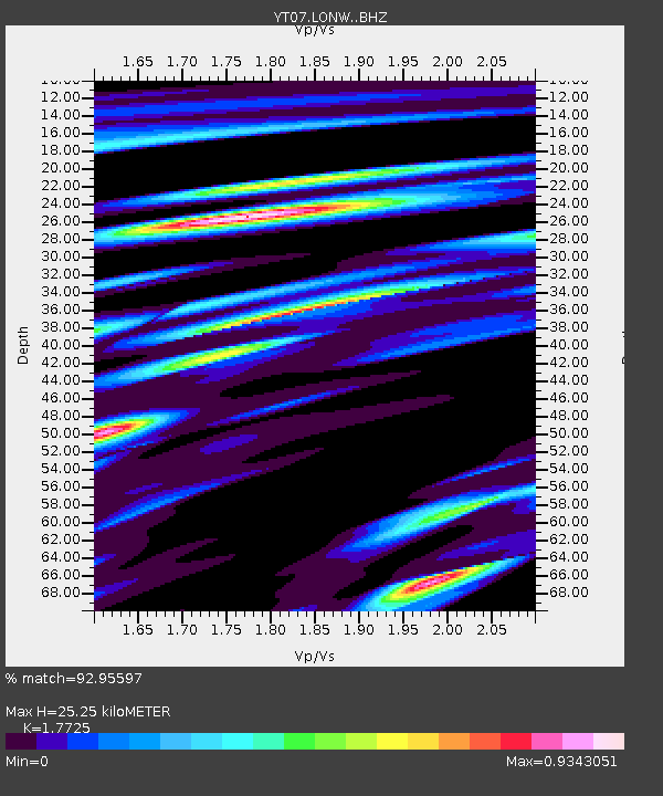
| Estimated Moho Depth: |
25.25 km |
| Estimated Crust Vp/Vs: |
1.77 |
| Assumed Crust Vp: |
6.306 km/s |
| Estimated Crust Vs: |
3.557 km/s |
| Estimated Crust Poisson's Ratio: |
0.27 |
|
| Radial Match: |
92.95597 % |
| Radial Bump: |
400 |
| Transverse Match: |
76.48386 % |
| Transverse Bump: |
400 |
| SOD ConfigId: |
3390531 |
| Insert Time: |
2019-04-14 22:18:24.437 +0000 |
| GWidth: |
2.5 |
| Max Bumps: |
400 |
| Tol: |
0.001 |
|

Signal To Noise
| Channel | StoN | STA | LTA |
| YT:LONW: :BHZ:20141110T10:13:50.899993Z | 14.206096 | 1.0772E-6 | 7.58266E-8 |
| YT:LONW: :BHN:20141110T10:13:50.899993Z | 9.87725 | 5.801542E-7 | 5.8736415E-8 |
| YT:LONW: :BHE:20141110T10:13:50.899993Z | 3.3560016 | 1.9982578E-7 | 5.9542817E-8 |
| Arrivals |
| Ps | 3.2 SECOND |
| PpPs | 11 SECOND |
| PsPs/PpSs | 14 SECOND |


