You are here: Home > Network List > YT07 - POLENET Stations List
> Station UNGL UNGL > Earthquake Result Viewer
UNGL UNGL - Earthquake Result Viewer
| Earthquake location: |
Southeast Of Loyalty Islands |
| Earthquake latitude/longitude: |
-22.8/171.4 |
| Earthquake time(UTC): |
2014/11/10 (314) 10:04:21 GMT |
| Earthquake Depth: |
10 km |
| Earthquake Magnitude: |
6.1 MWP |
| Earthquake Catalog/Contributor: |
NEIC PDE/NEIC COMCAT |
|
| Network: |
YT POLENET |
| Station: |
UNGL UNGL |
| Lat/Lon: |
79.77 S/82.52 W |
| Elevation: |
745 m |
|
| Distance: |
70.5 deg |
| Az: |
169.506 deg |
| Baz: |
250.189 deg |
| Ray Param: |
0.054916024 |
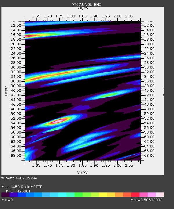
| Estimated Moho Depth: |
53.0 km |
| Estimated Crust Vp/Vs: |
1.74 |
| Assumed Crust Vp: |
6.182 km/s |
| Estimated Crust Vs: |
3.547 km/s |
| Estimated Crust Poisson's Ratio: |
0.25 |
|
| Radial Match: |
89.39244 % |
| Radial Bump: |
400 |
| Transverse Match: |
87.471985 % |
| Transverse Bump: |
400 |
| SOD ConfigId: |
3390531 |
| Insert Time: |
2019-04-14 22:18:33.566 +0000 |
| GWidth: |
2.5 |
| Max Bumps: |
400 |
| Tol: |
0.001 |
|

Signal To Noise
| Channel | StoN | STA | LTA |
| YT:UNGL: :BHZ:20141110T10:15:04.899993Z | 14.645849 | 8.4688077E-7 | 5.7823947E-8 |
| YT:UNGL: :BHN:20141110T10:15:04.899993Z | 2.511999 | 1.792248E-7 | 7.1347486E-8 |
| YT:UNGL: :BHE:20141110T10:15:04.899993Z | 7.3421154 | 4.0749475E-7 | 5.5500998E-8 |
| Arrivals |
| Ps | 6.6 SECOND |
| PpPs | 23 SECOND |
| PsPs/PpSs | 29 SECOND |


