You are here: Home > Network List > ZJ12 - Transantarctic Mountains Northern Network Stations List
> Station APRL East Antarctica > Earthquake Result Viewer
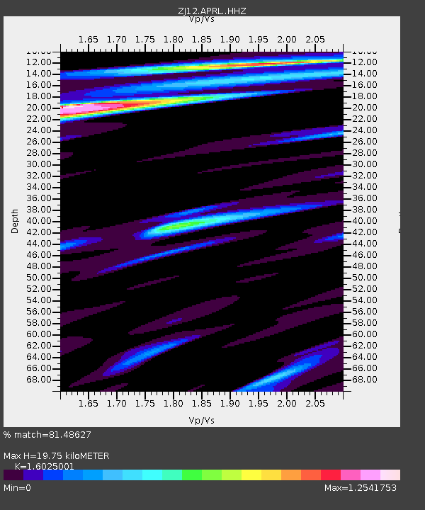
APRL East Antarctica - Earthquake Result Viewer
| Earthquake location: |
Southeast Of Loyalty Islands |
| Earthquake latitude/longitude: |
-22.8/171.4 |
| Earthquake time(UTC): |
2014/11/10 (314) 10:04:21 GMT |
| Earthquake Depth: |
10 km |
| Earthquake Magnitude: |
6.1 MWP |
| Earthquake Catalog/Contributor: |
NEIC PDE/NEIC COMCAT |
|
| Network: |
ZJ Transantarctic Mountains Northern Network |
| Station: |
APRL East Antarctica |
| Lat/Lon: |
73.19 S/158.70 E |
| Elevation: |
2258 m |
|
| Distance: |
50.9 deg |
| Az: |
184.74 deg |
| Baz: |
15.198 deg |
| Ray Param: |
0.06772512 |
| Estimated Moho Depth: |
19.75 km |
| Estimated Crust Vp/Vs: |
1.60 |
| Assumed Crust Vp: |
6.306 km/s |
| Estimated Crust Vs: |
3.935 km/s |
| Estimated Crust Poisson's Ratio: |
0.18 |
|
| Radial Match: |
81.48627 % |
| Radial Bump: |
400 |
| Transverse Match: |
84.33444 % |
| Transverse Bump: |
400 |
| SOD ConfigId: |
3390531 |
| Insert Time: |
2019-04-14 22:18:41.578 +0000 |
| GWidth: |
2.5 |
| Max Bumps: |
400 |
| Tol: |
0.001 |
|

Signal To Noise
| Channel | StoN | STA | LTA |
| ZJ:APRL: :HHZ:20141110T10:12:51.688994Z | 8.256769 | 1.922269E-6 | 2.3281127E-7 |
| ZJ:APRL: :HHN:20141110T10:12:51.688994Z | 6.8141794 | 6.987054E-7 | 1.0253699E-7 |
| ZJ:APRL: :HHE:20141110T10:12:51.688994Z | 3.436857 | 4.447589E-7 | 1.2940862E-7 |
| Arrivals |
| Ps | 2.0 SECOND |
| PpPs | 7.7 SECOND |
| PsPs/PpSs | 9.7 SECOND |


