You are here: Home > Network List > ZJ12 - Transantarctic Mountains Northern Network Stations List
> Station RAPH Exposure Hill, Antarctica > Earthquake Result Viewer
RAPH Exposure Hill, Antarctica - Earthquake Result Viewer
| Earthquake location: |
Southeast Of Loyalty Islands |
| Earthquake latitude/longitude: |
-22.8/171.4 |
| Earthquake time(UTC): |
2014/11/10 (314) 10:04:21 GMT |
| Earthquake Depth: |
10 km |
| Earthquake Magnitude: |
6.1 MWP |
| Earthquake Catalog/Contributor: |
NEIC PDE/NEIC COMCAT |
|
| Network: |
ZJ Transantarctic Mountains Northern Network |
| Station: |
RAPH Exposure Hill, Antarctica |
| Lat/Lon: |
73.60 S/162.29 E |
| Elevation: |
3052 m |
|
| Distance: |
51.1 deg |
| Az: |
183.331 deg |
| Baz: |
10.878 deg |
| Ray Param: |
0.06762438 |
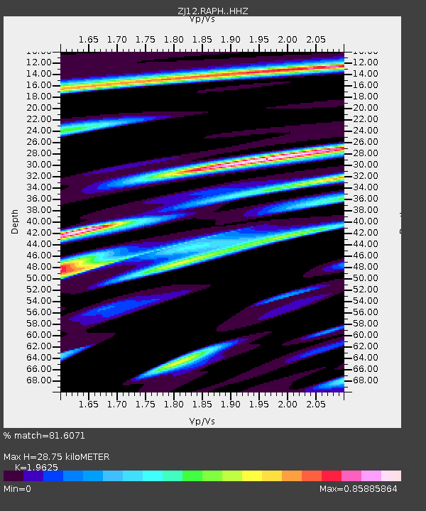
| Estimated Moho Depth: |
28.75 km |
| Estimated Crust Vp/Vs: |
1.96 |
| Assumed Crust Vp: |
6.264 km/s |
| Estimated Crust Vs: |
3.192 km/s |
| Estimated Crust Poisson's Ratio: |
0.32 |
|
| Radial Match: |
81.6071 % |
| Radial Bump: |
391 |
| Transverse Match: |
66.78715 % |
| Transverse Bump: |
400 |
| SOD ConfigId: |
3390531 |
| Insert Time: |
2019-04-14 22:18:46.331 +0000 |
| GWidth: |
2.5 |
| Max Bumps: |
400 |
| Tol: |
0.001 |
|

Signal To Noise
| Channel | StoN | STA | LTA |
| ZJ:RAPH: :HHZ:20141110T10:12:52.890013Z | 12.436479 | 1.2928396E-6 | 1.0395544E-7 |
| ZJ:RAPH: :HHN:20141110T10:12:52.890013Z | 5.7716217 | 6.4254516E-7 | 1.1132835E-7 |
| ZJ:RAPH: :HHE:20141110T10:12:52.890013Z | 1.1296211 | 1.3998111E-7 | 1.2391862E-7 |
| Arrivals |
| Ps | 4.6 SECOND |
| PpPs | 13 SECOND |
| PsPs/PpSs | 18 SECOND |


