You are here: Home > Network List > TA - USArray Transportable Network (new EarthScope stations) Stations List
> Station R52A Catlettsburg, KY, USA > Earthquake Result Viewer
R52A Catlettsburg, KY, USA - Earthquake Result Viewer
| Earthquake location: |
Northern Chile |
| Earthquake latitude/longitude: |
-22.3/-68.6 |
| Earthquake time(UTC): |
2013/08/23 (235) 08:34:06 GMT |
| Earthquake Depth: |
111 km |
| Earthquake Magnitude: |
5.8 MWW, 5.7 MWD, 5.8 MWW, 5.8 MWB, 5.8 MWC |
| Earthquake Catalog/Contributor: |
NEIC PDE/NEIC COMCAT |
|
| Network: |
TA USArray Transportable Network (new EarthScope stations) |
| Station: |
R52A Catlettsburg, KY, USA |
| Lat/Lon: |
38.34 N/82.64 W |
| Elevation: |
300 m |
|
| Distance: |
61.7 deg |
| Az: |
347.478 deg |
| Baz: |
165.204 deg |
| Ray Param: |
0.060384594 |
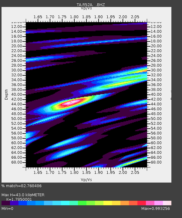
| Estimated Moho Depth: |
43.0 km |
| Estimated Crust Vp/Vs: |
1.79 |
| Assumed Crust Vp: |
6.232 km/s |
| Estimated Crust Vs: |
3.491 km/s |
| Estimated Crust Poisson's Ratio: |
0.27 |
|
| Radial Match: |
82.768486 % |
| Radial Bump: |
400 |
| Transverse Match: |
65.21816 % |
| Transverse Bump: |
400 |
| SOD ConfigId: |
626651 |
| Insert Time: |
2014-04-18 02:52:56.216 +0000 |
| GWidth: |
2.5 |
| Max Bumps: |
400 |
| Tol: |
0.001 |
|

Signal To Noise
| Channel | StoN | STA | LTA |
| TA:R52A: :BHZ:20130823T08:43:42.724993Z | 4.3659916 | 3.736684E-7 | 8.5586144E-8 |
| TA:R52A: :BHN:20130823T08:43:42.724993Z | 2.1594808 | 2.3406471E-7 | 1.08389344E-7 |
| TA:R52A: :BHE:20130823T08:43:42.724993Z | 0.8819999 | 1.224851E-7 | 1.3887202E-7 |
| Arrivals |
| Ps | 5.6 SECOND |
| PpPs | 18 SECOND |
| PsPs/PpSs | 24 SECOND |


