You are here: Home > Network List > TA - USArray Transportable Network (new EarthScope stations) Stations List
> Station T56A Rocky Mt, VA, USA > Earthquake Result Viewer
T56A Rocky Mt, VA, USA - Earthquake Result Viewer
| Earthquake location: |
Northern Chile |
| Earthquake latitude/longitude: |
-22.3/-68.6 |
| Earthquake time(UTC): |
2013/08/23 (235) 08:34:06 GMT |
| Earthquake Depth: |
111 km |
| Earthquake Magnitude: |
5.8 MWW, 5.7 MWD, 5.8 MWW, 5.8 MWB, 5.8 MWC |
| Earthquake Catalog/Contributor: |
NEIC PDE/NEIC COMCAT |
|
| Network: |
TA USArray Transportable Network (new EarthScope stations) |
| Station: |
T56A Rocky Mt, VA, USA |
| Lat/Lon: |
37.03 N/80.03 W |
| Elevation: |
387 m |
|
| Distance: |
60.0 deg |
| Az: |
349.436 deg |
| Baz: |
167.749 deg |
| Ray Param: |
0.061520226 |
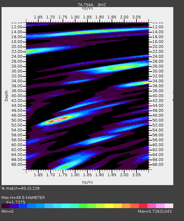
| Estimated Moho Depth: |
49.5 km |
| Estimated Crust Vp/Vs: |
1.73 |
| Assumed Crust Vp: |
6.159 km/s |
| Estimated Crust Vs: |
3.565 km/s |
| Estimated Crust Poisson's Ratio: |
0.25 |
|
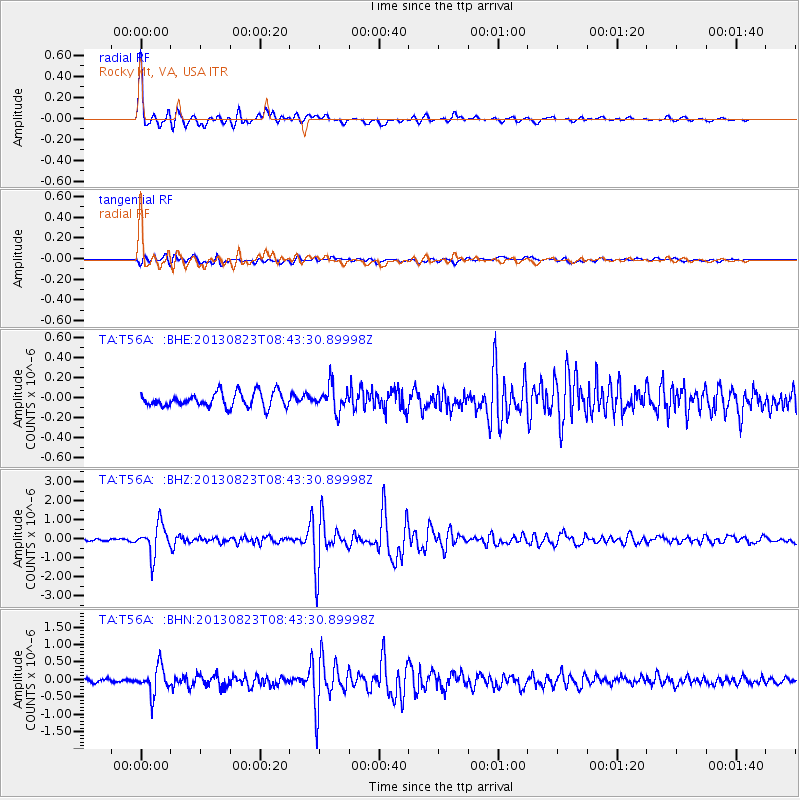
| Radial Match: |
95.01229 % |
| Radial Bump: |
362 |
| Transverse Match: |
67.725105 % |
| Transverse Bump: |
400 |
| SOD ConfigId: |
626651 |
| Insert Time: |
2014-04-18 02:55:05.400 +0000 |
| GWidth: |
2.5 |
| Max Bumps: |
400 |
| Tol: |
0.001 |
|
Signal To Noise
| Channel | StoN | STA | LTA |
| TA:T56A: :BHZ:20130823T08:43:30.89998Z | 16.230623 | 7.839855E-7 | 4.8302855E-8 |
| TA:T56A: :BHN:20130823T08:43:30.89998Z | 8.464732 | 3.754753E-7 | 4.435761E-8 |
| TA:T56A: :BHE:20130823T08:43:30.89998Z | 1.6839917 | 1.214801E-7 | 7.213818E-8 |
| Arrivals |
| Ps | 6.1 SECOND |
| PpPs | 21 SECOND |
| PsPs/PpSs | 27 SECOND |


