You are here: Home > Network List > TA - USArray Transportable Network (new EarthScope stations) Stations List
> Station U50A Jamestown, TN, USA > Earthquake Result Viewer
U50A Jamestown, TN, USA - Earthquake Result Viewer
| Earthquake location: |
Northern Chile |
| Earthquake latitude/longitude: |
-22.3/-68.6 |
| Earthquake time(UTC): |
2013/08/23 (235) 08:34:06 GMT |
| Earthquake Depth: |
111 km |
| Earthquake Magnitude: |
5.8 MWW, 5.7 MWD, 5.8 MWW, 5.8 MWB, 5.8 MWC |
| Earthquake Catalog/Contributor: |
NEIC PDE/NEIC COMCAT |
|
| Network: |
TA USArray Transportable Network (new EarthScope stations) |
| Station: |
U50A Jamestown, TN, USA |
| Lat/Lon: |
36.42 N/84.84 W |
| Elevation: |
474 m |
|
| Distance: |
60.4 deg |
| Az: |
344.947 deg |
| Baz: |
162.649 deg |
| Ray Param: |
0.061259832 |
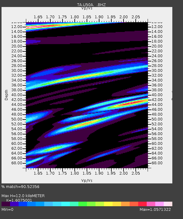
| Estimated Moho Depth: |
12.0 km |
| Estimated Crust Vp/Vs: |
1.61 |
| Assumed Crust Vp: |
6.476 km/s |
| Estimated Crust Vs: |
4.029 km/s |
| Estimated Crust Poisson's Ratio: |
0.18 |
|
| Radial Match: |
90.52356 % |
| Radial Bump: |
400 |
| Transverse Match: |
75.71778 % |
| Transverse Bump: |
400 |
| SOD ConfigId: |
626651 |
| Insert Time: |
2014-04-18 02:55:49.472 +0000 |
| GWidth: |
2.5 |
| Max Bumps: |
400 |
| Tol: |
0.001 |
|

Signal To Noise
| Channel | StoN | STA | LTA |
| TA:U50A: :BHZ:20130823T08:43:33.599016Z | 10.795319 | 5.97488E-7 | 5.5346952E-8 |
| TA:U50A: :BHN:20130823T08:43:33.599016Z | 5.679538 | 2.9254718E-7 | 5.1508977E-8 |
| TA:U50A: :BHE:20130823T08:43:33.599016Z | 1.8346417 | 9.1465296E-8 | 4.985458E-8 |
| Arrivals |
| Ps | 1.2 SECOND |
| PpPs | 4.6 SECOND |
| PsPs/PpSs | 5.8 SECOND |


