You are here: Home > Network List > TA - USArray Transportable Network (new EarthScope stations) Stations List
> Station U57A Blanch, NC, USA > Earthquake Result Viewer
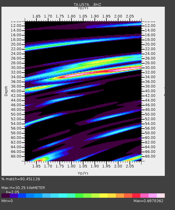
U57A Blanch, NC, USA - Earthquake Result Viewer
| Earthquake location: |
Northern Chile |
| Earthquake latitude/longitude: |
-22.3/-68.6 |
| Earthquake time(UTC): |
2013/08/23 (235) 08:34:06 GMT |
| Earthquake Depth: |
111 km |
| Earthquake Magnitude: |
5.8 MWW, 5.7 MWD, 5.8 MWW, 5.8 MWB, 5.8 MWC |
| Earthquake Catalog/Contributor: |
NEIC PDE/NEIC COMCAT |
|
| Network: |
TA USArray Transportable Network (new EarthScope stations) |
| Station: |
U57A Blanch, NC, USA |
| Lat/Lon: |
36.43 N/79.34 W |
| Elevation: |
178 m |
|
| Distance: |
59.3 deg |
| Az: |
349.927 deg |
| Baz: |
168.411 deg |
| Ray Param: |
0.0619747 |
| Estimated Moho Depth: |
30.25 km |
| Estimated Crust Vp/Vs: |
2.05 |
| Assumed Crust Vp: |
6.419 km/s |
| Estimated Crust Vs: |
3.131 km/s |
| Estimated Crust Poisson's Ratio: |
0.34 |
|
| Radial Match: |
90.451126 % |
| Radial Bump: |
281 |
| Transverse Match: |
49.88063 % |
| Transverse Bump: |
400 |
| SOD ConfigId: |
626651 |
| Insert Time: |
2014-04-18 02:56:07.654 +0000 |
| GWidth: |
2.5 |
| Max Bumps: |
400 |
| Tol: |
0.001 |
|

Signal To Noise
| Channel | StoN | STA | LTA |
| TA:U57A: :BHZ:20130823T08:43:26.099993Z | 7.1078877 | 4.7994985E-7 | 6.752356E-8 |
| TA:U57A: :BHN:20130823T08:43:26.099993Z | 5.8886867 | 3.0434643E-7 | 5.1683244E-8 |
| TA:U57A: :BHE:20130823T08:43:26.099993Z | 1.7314677 | 1.494682E-7 | 8.632457E-8 |
| Arrivals |
| Ps | 5.2 SECOND |
| PpPs | 14 SECOND |
| PsPs/PpSs | 19 SECOND |


