You are here: Home > Network List > TA - USArray Transportable Network (new EarthScope stations) Stations List
> Station V54A Nebo, NC, USA > Earthquake Result Viewer
V54A Nebo, NC, USA - Earthquake Result Viewer
| Earthquake location: |
Northern Chile |
| Earthquake latitude/longitude: |
-22.3/-68.6 |
| Earthquake time(UTC): |
2013/08/23 (235) 08:34:06 GMT |
| Earthquake Depth: |
111 km |
| Earthquake Magnitude: |
5.8 MWW, 5.7 MWD, 5.8 MWW, 5.8 MWB, 5.8 MWC |
| Earthquake Catalog/Contributor: |
NEIC PDE/NEIC COMCAT |
|
| Network: |
TA USArray Transportable Network (new EarthScope stations) |
| Station: |
V54A Nebo, NC, USA |
| Lat/Lon: |
35.78 N/81.95 W |
| Elevation: |
448 m |
|
| Distance: |
59.1 deg |
| Az: |
347.356 deg |
| Baz: |
165.562 deg |
| Ray Param: |
0.062078692 |
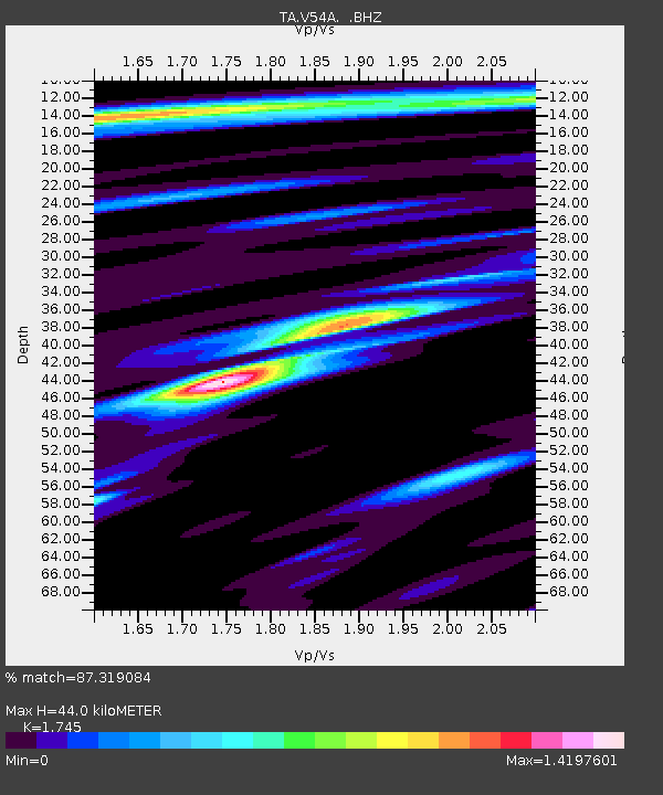
| Estimated Moho Depth: |
44.0 km |
| Estimated Crust Vp/Vs: |
1.75 |
| Assumed Crust Vp: |
6.419 km/s |
| Estimated Crust Vs: |
3.679 km/s |
| Estimated Crust Poisson's Ratio: |
0.26 |
|
| Radial Match: |
87.319084 % |
| Radial Bump: |
400 |
| Transverse Match: |
71.6329 % |
| Transverse Bump: |
400 |
| SOD ConfigId: |
626651 |
| Insert Time: |
2014-04-18 02:56:42.142 +0000 |
| GWidth: |
2.5 |
| Max Bumps: |
400 |
| Tol: |
0.001 |
|

Signal To Noise
| Channel | StoN | STA | LTA |
| TA:V54A: :BHZ:20130823T08:43:25.000017Z | 10.322845 | 5.971897E-7 | 5.785127E-8 |
| TA:V54A: :BHN:20130823T08:43:25.000017Z | 6.2571125 | 2.5148714E-7 | 4.0192205E-8 |
| TA:V54A: :BHE:20130823T08:43:25.000017Z | 1.3753637 | 1.1345217E-7 | 8.2488846E-8 |
| Arrivals |
| Ps | 5.4 SECOND |
| PpPs | 18 SECOND |
| PsPs/PpSs | 23 SECOND |


