You are here: Home > Network List > TA - USArray Transportable Network (new EarthScope stations) Stations List
> Station V61A Roper, NC, USA > Earthquake Result Viewer
V61A Roper, NC, USA - Earthquake Result Viewer
| Earthquake location: |
Northern Chile |
| Earthquake latitude/longitude: |
-22.3/-68.6 |
| Earthquake time(UTC): |
2013/08/23 (235) 08:34:06 GMT |
| Earthquake Depth: |
111 km |
| Earthquake Magnitude: |
5.8 MWW, 5.7 MWD, 5.8 MWW, 5.8 MWB, 5.8 MWC |
| Earthquake Catalog/Contributor: |
NEIC PDE/NEIC COMCAT |
|
| Network: |
TA USArray Transportable Network (new EarthScope stations) |
| Station: |
V61A Roper, NC, USA |
| Lat/Lon: |
35.79 N/76.58 W |
| Elevation: |
4.0 m |
|
| Distance: |
58.2 deg |
| Az: |
352.367 deg |
| Baz: |
171.296 deg |
| Ray Param: |
0.06264284 |
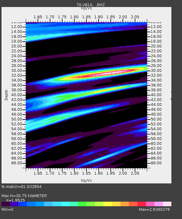
| Estimated Moho Depth: |
30.75 km |
| Estimated Crust Vp/Vs: |
1.95 |
| Assumed Crust Vp: |
6.565 km/s |
| Estimated Crust Vs: |
3.362 km/s |
| Estimated Crust Poisson's Ratio: |
0.32 |
|
| Radial Match: |
81.832954 % |
| Radial Bump: |
400 |
| Transverse Match: |
51.64705 % |
| Transverse Bump: |
387 |
| SOD ConfigId: |
626651 |
| Insert Time: |
2014-04-18 02:57:03.590 +0000 |
| GWidth: |
2.5 |
| Max Bumps: |
400 |
| Tol: |
0.001 |
|

Signal To Noise
| Channel | StoN | STA | LTA |
| TA:V61A: :BHZ:20130823T08:43:19.050005Z | 2.5009875 | 4.4589808E-7 | 1.7828881E-7 |
| TA:V61A: :BHN:20130823T08:43:19.050005Z | 1.915522 | 5.276169E-7 | 2.754429E-7 |
| TA:V61A: :BHE:20130823T08:43:19.050005Z | 0.5978404 | 2.5908852E-7 | 4.3337403E-7 |
| Arrivals |
| Ps | 4.7 SECOND |
| PpPs | 13 SECOND |
| PsPs/PpSs | 18 SECOND |


