You are here: Home > Network List > TA - USArray Transportable Network (new EarthScope stations) Stations List
> Station X60A Albert Glenn Thornton, NC, USA > Earthquake Result Viewer
X60A Albert Glenn Thornton, NC, USA - Earthquake Result Viewer

| Earthquake location: |
Northern Chile |
| Earthquake latitude/longitude: |
-22.3/-68.6 |
| Earthquake time(UTC): |
2013/08/23 (235) 08:34:06 GMT |
| Earthquake Depth: |
111 km |
| Earthquake Magnitude: |
5.8 MWW, 5.7 MWD, 5.8 MWW, 5.8 MWB, 5.8 MWC |
| Earthquake Catalog/Contributor: |
NEIC PDE/NEIC COMCAT |
|
| Network: |
TA USArray Transportable Network (new EarthScope stations) |
| Station: |
X60A Albert Glenn Thornton, NC, USA |
| Lat/Lon: |
34.58 N/77.98 W |
| Elevation: |
12 m |
|
| Distance: |
57.2 deg |
| Az: |
350.794 deg |
| Baz: |
169.653 deg |
| Ray Param: |
0.06329235 |
| Estimated Moho Depth: |
22.0 km |
| Estimated Crust Vp/Vs: |
1.65 |
| Assumed Crust Vp: |
6.565 km/s |
| Estimated Crust Vs: |
3.966 km/s |
| Estimated Crust Poisson's Ratio: |
0.21 |
|
| Radial Match: |
84.958496 % |
| Radial Bump: |
400 |
| Transverse Match: |
60.474503 % |
| Transverse Bump: |
400 |
| SOD ConfigId: |
626651 |
| Insert Time: |
2014-04-18 02:58:41.291 +0000 |
| GWidth: |
2.5 |
| Max Bumps: |
400 |
| Tol: |
0.001 |
|
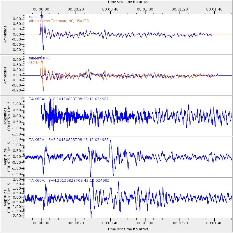
Signal To Noise
| Channel | StoN | STA | LTA |
| TA:X60A: :BHZ:20130823T08:43:12.02498Z | 3.3517141 | 5.4699143E-7 | 1.6319751E-7 |
| TA:X60A: :BHN:20130823T08:43:12.02498Z | 1.5661863 | 6.4217215E-7 | 4.1002286E-7 |
| TA:X60A: :BHE:20130823T08:43:12.02498Z | 0.9286662 | 3.7576734E-7 | 4.0463124E-7 |
| Arrivals |
| Ps | 2.3 SECOND |
| PpPs | 8.4 SECOND |
| PsPs/PpSs | 11 SECOND |


