You are here: Home > Network List > TA - USArray Transportable Network (new EarthScope stations) Stations List
> Station Z50A Ashland, AL, USA > Earthquake Result Viewer
Z50A Ashland, AL, USA - Earthquake Result Viewer
| Earthquake location: |
Northern Chile |
| Earthquake latitude/longitude: |
-22.3/-68.6 |
| Earthquake time(UTC): |
2013/08/23 (235) 08:34:06 GMT |
| Earthquake Depth: |
111 km |
| Earthquake Magnitude: |
5.8 MWW, 5.7 MWD, 5.8 MWW, 5.8 MWB, 5.8 MWC |
| Earthquake Catalog/Contributor: |
NEIC PDE/NEIC COMCAT |
|
| Network: |
TA USArray Transportable Network (new EarthScope stations) |
| Station: |
Z50A Ashland, AL, USA |
| Lat/Lon: |
33.25 N/85.92 W |
| Elevation: |
370 m |
|
| Distance: |
57.6 deg |
| Az: |
342.813 deg |
| Baz: |
160.935 deg |
| Ray Param: |
0.06303216 |
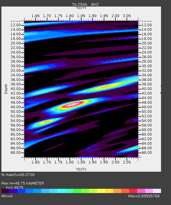
| Estimated Moho Depth: |
46.75 km |
| Estimated Crust Vp/Vs: |
1.81 |
| Assumed Crust Vp: |
6.719 km/s |
| Estimated Crust Vs: |
3.717 km/s |
| Estimated Crust Poisson's Ratio: |
0.28 |
|
| Radial Match: |
88.0738 % |
| Radial Bump: |
400 |
| Transverse Match: |
65.39186 % |
| Transverse Bump: |
400 |
| SOD ConfigId: |
626651 |
| Insert Time: |
2014-04-18 02:59:26.226 +0000 |
| GWidth: |
2.5 |
| Max Bumps: |
400 |
| Tol: |
0.001 |
|

Signal To Noise
| Channel | StoN | STA | LTA |
| TA:Z50A: :BHZ:20130823T08:43:14.849993Z | 14.621982 | 6.2565607E-7 | 4.278873E-8 |
| TA:Z50A: :BHN:20130823T08:43:14.849993Z | 9.592412 | 3.1115587E-7 | 3.243771E-8 |
| TA:Z50A: :BHE:20130823T08:43:14.849993Z | 2.4519992 | 1.232684E-7 | 5.0272615E-8 |
| Arrivals |
| Ps | 5.9 SECOND |
| PpPs | 19 SECOND |
| PsPs/PpSs | 24 SECOND |


