You are here: Home > Network List > TA - USArray Transportable Network (new EarthScope stations) Stations List
> Station Z59A Georgetown, SC, USA > Earthquake Result Viewer
Z59A Georgetown, SC, USA - Earthquake Result Viewer
| Earthquake location: |
Northern Chile |
| Earthquake latitude/longitude: |
-22.3/-68.6 |
| Earthquake time(UTC): |
2013/08/23 (235) 08:34:06 GMT |
| Earthquake Depth: |
111 km |
| Earthquake Magnitude: |
5.8 MWW, 5.7 MWD, 5.8 MWW, 5.8 MWB, 5.8 MWC |
| Earthquake Catalog/Contributor: |
NEIC PDE/NEIC COMCAT |
|
| Network: |
TA USArray Transportable Network (new EarthScope stations) |
| Station: |
Z59A Georgetown, SC, USA |
| Lat/Lon: |
33.24 N/79.28 W |
| Elevation: |
8.0 m |
|
| Distance: |
56.1 deg |
| Az: |
349.215 deg |
| Baz: |
168.064 deg |
| Ray Param: |
0.06399766 |
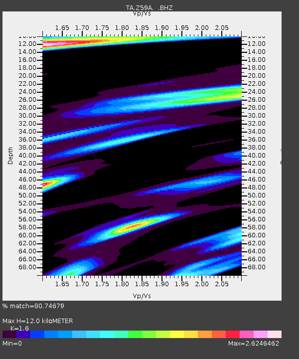
| Estimated Moho Depth: |
12.0 km |
| Estimated Crust Vp/Vs: |
1.60 |
| Assumed Crust Vp: |
6.24 km/s |
| Estimated Crust Vs: |
3.9 km/s |
| Estimated Crust Poisson's Ratio: |
0.18 |
|
| Radial Match: |
80.74679 % |
| Radial Bump: |
378 |
| Transverse Match: |
51.08082 % |
| Transverse Bump: |
400 |
| SOD ConfigId: |
626651 |
| Insert Time: |
2014-04-18 02:59:59.719 +0000 |
| GWidth: |
2.5 |
| Max Bumps: |
400 |
| Tol: |
0.001 |
|
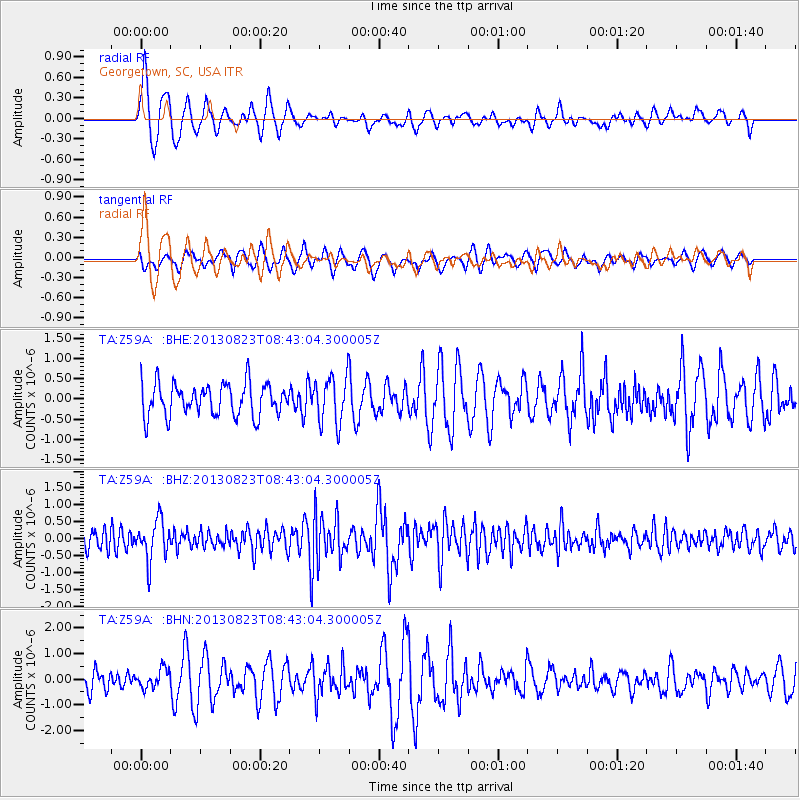
Signal To Noise
| Channel | StoN | STA | LTA |
| TA:Z59A: :BHZ:20130823T08:43:04.300005Z | 2.507891 | 5.9479305E-7 | 2.3716862E-7 |
| TA:Z59A: :BHN:20130823T08:43:04.300005Z | 0.99369097 | 3.683054E-7 | 3.706438E-7 |
| TA:Z59A: :BHE:20130823T08:43:04.300005Z | 1.4816241 | 5.8465474E-7 | 3.9460397E-7 |
| Arrivals |
| Ps | 1.2 SECOND |
| PpPs | 4.7 SECOND |
| PsPs/PpSs | 6.0 SECOND |


