You are here: Home > Network List > TA - USArray Transportable Network (new EarthScope stations) Stations List
> Station G59A Clarenceville, QC, USA > Earthquake Result Viewer
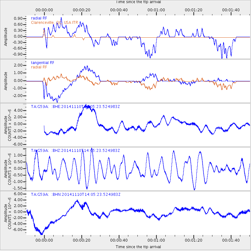
G59A Clarenceville, QC, USA - Earthquake Result Viewer
*The percent match for this event was below the threshold and hence no stack was calculated.
| Earthquake location: |
Southern Iran |
| Earthquake latitude/longitude: |
27.9/55.9 |
| Earthquake time(UTC): |
2014/11/10 (314) 13:52:37 GMT |
| Earthquake Depth: |
11 km |
| Earthquake Magnitude: |
5.2 MW, 5.3 mb, 4.8 MS |
| Earthquake Catalog/Contributor: |
ISC/ISC |
|
| Network: |
TA USArray Transportable Network (new EarthScope stations) |
| Station: |
G59A Clarenceville, QC, USA |
| Lat/Lon: |
45.08 N/73.18 W |
| Elevation: |
36 m |
|
| Distance: |
93.8 deg |
| Az: |
326.552 deg |
| Baz: |
43.526 deg |
| Ray Param: |
$rayparam |
*The percent match for this event was below the threshold and hence was not used in the summary stack. |
|
| Radial Match: |
17.183569 % |
| Radial Bump: |
400 |
| Transverse Match: |
25.166975 % |
| Transverse Bump: |
400 |
| SOD ConfigId: |
3390531 |
| Insert Time: |
2019-04-14 22:31:16.198 +0000 |
| GWidth: |
2.5 |
| Max Bumps: |
400 |
| Tol: |
0.001 |
|
Signal To Noise
| Channel | StoN | STA | LTA |
| TA:G59A: :BHZ:20141110T14:05:23.524983Z | 0.9613525 | 4.4899758E-7 | 4.670478E-7 |
| TA:G59A: :BHN:20141110T14:05:23.524983Z | 2.6143699 | 9.191004E-6 | 3.5155715E-6 |
| TA:G59A: :BHE:20141110T14:05:23.524983Z | 0.29500937 | 8.588732E-7 | 2.911342E-6 |
| Arrivals |
| Ps | |
| PpPs | |
| PsPs/PpSs | |


