You are here: Home > Network List > US - United States National Seismic Network Stations List
> Station RLMT Red Lodge, Montana, USA > Earthquake Result Viewer
RLMT Red Lodge, Montana, USA - Earthquake Result Viewer
| Earthquake location: |
Northern Chile |
| Earthquake latitude/longitude: |
-22.3/-68.6 |
| Earthquake time(UTC): |
2013/08/23 (235) 08:34:06 GMT |
| Earthquake Depth: |
111 km |
| Earthquake Magnitude: |
5.8 MWW, 5.7 MWD, 5.8 MWW, 5.8 MWB, 5.8 MWC |
| Earthquake Catalog/Contributor: |
NEIC PDE/NEIC COMCAT |
|
| Network: |
US United States National Seismic Network |
| Station: |
RLMT Red Lodge, Montana, USA |
| Lat/Lon: |
45.12 N/109.27 W |
| Elevation: |
2086 m |
|
| Distance: |
76.6 deg |
| Az: |
331.687 deg |
| Baz: |
141.646 deg |
| Ray Param: |
0.050603677 |
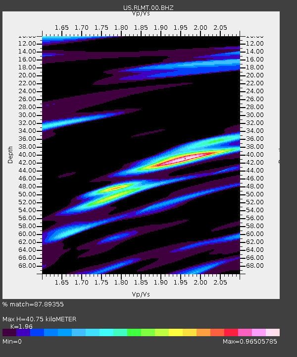
| Estimated Moho Depth: |
40.75 km |
| Estimated Crust Vp/Vs: |
1.96 |
| Assumed Crust Vp: |
6.242 km/s |
| Estimated Crust Vs: |
3.185 km/s |
| Estimated Crust Poisson's Ratio: |
0.32 |
|
| Radial Match: |
87.89355 % |
| Radial Bump: |
400 |
| Transverse Match: |
81.01173 % |
| Transverse Bump: |
400 |
| SOD ConfigId: |
626651 |
| Insert Time: |
2014-04-18 03:02:45.100 +0000 |
| GWidth: |
2.5 |
| Max Bumps: |
400 |
| Tol: |
0.001 |
|

Signal To Noise
| Channel | StoN | STA | LTA |
| US:RLMT:00:BHZ:20130823T08:45:14.498979Z | 16.976196 | 9.250774E-7 | 5.4492617E-8 |
| US:RLMT:00:BH1:20130823T08:45:14.498979Z | 4.891384 | 3.083573E-7 | 6.3040915E-8 |
| US:RLMT:00:BH2:20130823T08:45:14.498979Z | 3.7851202 | 2.7806718E-7 | 7.3463234E-8 |
| Arrivals |
| Ps | 6.4 SECOND |
| PpPs | 19 SECOND |
| PsPs/PpSs | 25 SECOND |


