You are here: Home > Network List > TA - USArray Transportable Network (new EarthScope stations) Stations List
> Station N60A Cedar Hill Farm, Mount Bethel, PA, USA > Earthquake Result Viewer
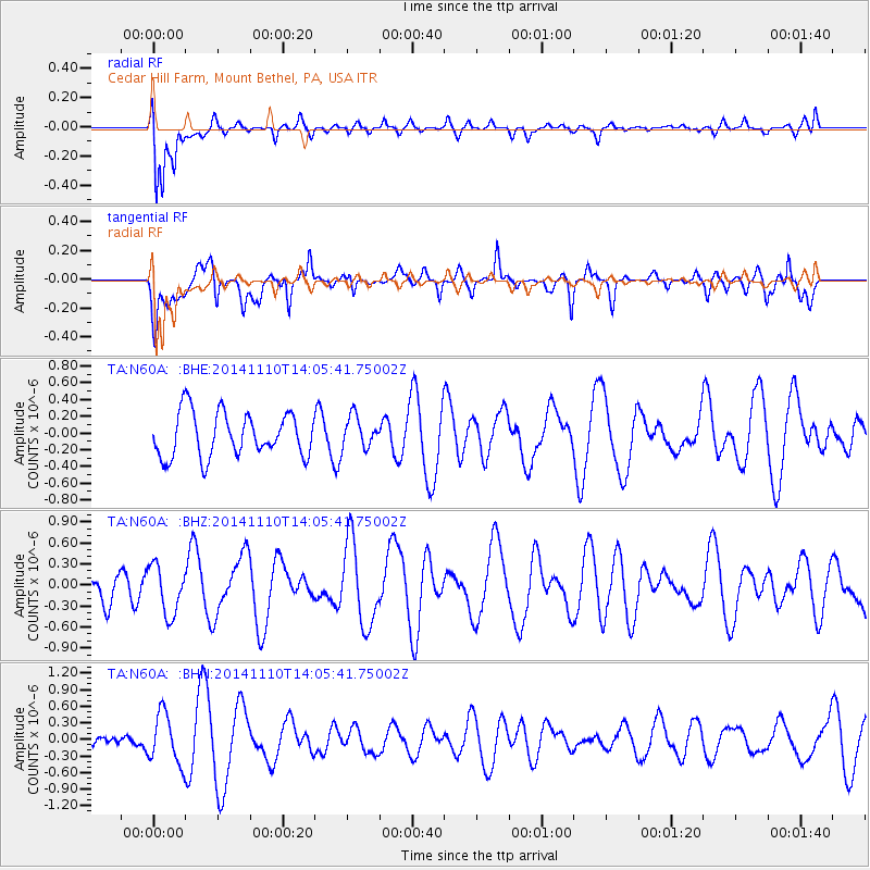
N60A Cedar Hill Farm, Mount Bethel, PA, USA - Earthquake Result Viewer
*The percent match for this event was below the threshold and hence no stack was calculated.
| Earthquake location: |
Southern Iran |
| Earthquake latitude/longitude: |
27.9/55.9 |
| Earthquake time(UTC): |
2014/11/10 (314) 13:52:37 GMT |
| Earthquake Depth: |
11 km |
| Earthquake Magnitude: |
5.2 MW, 5.3 mb, 4.8 MS |
| Earthquake Catalog/Contributor: |
ISC/ISC |
|
| Network: |
TA USArray Transportable Network (new EarthScope stations) |
| Station: |
N60A Cedar Hill Farm, Mount Bethel, PA, USA |
| Lat/Lon: |
40.87 N/75.10 W |
| Elevation: |
189 m |
|
| Distance: |
97.9 deg |
| Az: |
324.706 deg |
| Baz: |
42.41 deg |
| Ray Param: |
$rayparam |
*The percent match for this event was below the threshold and hence was not used in the summary stack. |
|
| Radial Match: |
72.48474 % |
| Radial Bump: |
400 |
| Transverse Match: |
47.684406 % |
| Transverse Bump: |
400 |
| SOD ConfigId: |
3390531 |
| Insert Time: |
2019-04-14 22:31:27.352 +0000 |
| GWidth: |
2.5 |
| Max Bumps: |
400 |
| Tol: |
0.001 |
|
Signal To Noise
| Channel | StoN | STA | LTA |
| TA:N60A: :BHZ:20141110T14:05:41.75002Z | 1.0182106 | 3.4630008E-7 | 3.4010654E-7 |
| TA:N60A: :BHN:20141110T14:05:41.75002Z | 2.8979177 | 4.525066E-7 | 1.5614889E-7 |
| TA:N60A: :BHE:20141110T14:05:41.75002Z | 0.71112126 | 1.8748482E-7 | 2.6364677E-7 |
| Arrivals |
| Ps | |
| PpPs | |
| PsPs/PpSs | |


