You are here: Home > Network List > UU - University of Utah Regional Network Stations List
> Station HMU Henry Mountain, UT, USA > Earthquake Result Viewer
HMU Henry Mountain, UT, USA - Earthquake Result Viewer
| Earthquake location: |
Northern Chile |
| Earthquake latitude/longitude: |
-22.3/-68.6 |
| Earthquake time(UTC): |
2013/08/23 (235) 08:34:06 GMT |
| Earthquake Depth: |
111 km |
| Earthquake Magnitude: |
5.8 MWW, 5.7 MWD, 5.8 MWW, 5.8 MWB, 5.8 MWC |
| Earthquake Catalog/Contributor: |
NEIC PDE/NEIC COMCAT |
|
| Network: |
UU University of Utah Regional Network |
| Station: |
HMU Henry Mountain, UT, USA |
| Lat/Lon: |
37.94 N/110.74 W |
| Elevation: |
2430 m |
|
| Distance: |
71.8 deg |
| Az: |
326.047 deg |
| Baz: |
139.133 deg |
| Ray Param: |
0.0538042 |
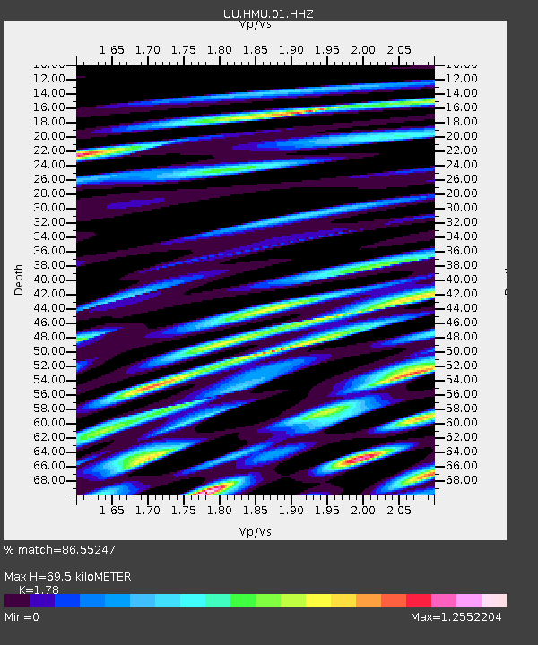
| Estimated Moho Depth: |
69.5 km |
| Estimated Crust Vp/Vs: |
1.78 |
| Assumed Crust Vp: |
6.247 km/s |
| Estimated Crust Vs: |
3.509 km/s |
| Estimated Crust Poisson's Ratio: |
0.27 |
|
| Radial Match: |
86.55247 % |
| Radial Bump: |
400 |
| Transverse Match: |
75.034744 % |
| Transverse Bump: |
400 |
| SOD ConfigId: |
626651 |
| Insert Time: |
2014-04-18 03:03:25.127 +0000 |
| GWidth: |
2.5 |
| Max Bumps: |
400 |
| Tol: |
0.001 |
|

Signal To Noise
| Channel | StoN | STA | LTA |
| UU:HMU:01:HHZ:20130823T08:44:46.560991Z | 13.486159 | 3.2802088E-8 | 2.432278E-9 |
| UU:HMU:01:HHN:20130823T08:44:46.560991Z | 5.0078363 | 1.0706219E-8 | 2.137893E-9 |
| UU:HMU:01:HHE:20130823T08:44:46.560991Z | 6.206724 | 1.3908016E-8 | 2.2407982E-9 |
| Arrivals |
| Ps | 9.0 SECOND |
| PpPs | 30 SECOND |
| PsPs/PpSs | 39 SECOND |


