You are here: Home > Network List > CI - Caltech Regional Seismic Network Stations List
> Station TIN Tinemaha, California, USA > Earthquake Result Viewer
TIN Tinemaha, California, USA - Earthquake Result Viewer
| Earthquake location: |
Santa Cruz Islands |
| Earthquake latitude/longitude: |
-12.9/166.7 |
| Earthquake time(UTC): |
1999/02/06 (037) 21:47:59 GMT |
| Earthquake Depth: |
90 km |
| Earthquake Magnitude: |
6.3 MB, 7.3 MS, 7.4 MW, 7.0 ME |
| Earthquake Catalog/Contributor: |
WHDF/NEIC |
|
| Network: |
CI Caltech Regional Seismic Network |
| Station: |
TIN Tinemaha, California, USA |
| Lat/Lon: |
37.05 N/118.23 W |
| Elevation: |
1164 m |
|
| Distance: |
86.1 deg |
| Az: |
50.789 deg |
| Baz: |
250.833 deg |
| Ray Param: |
0.04412359 |
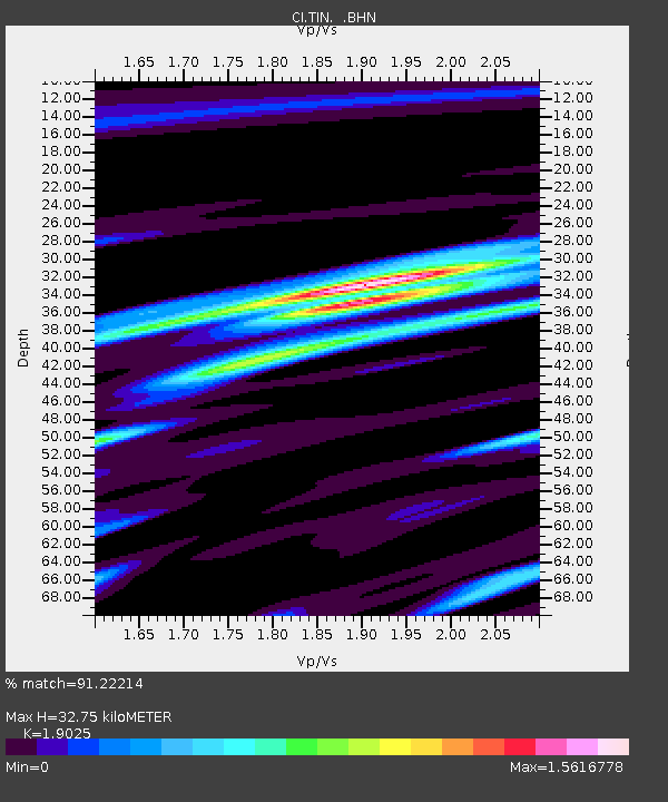
| Estimated Moho Depth: |
32.75 km |
| Estimated Crust Vp/Vs: |
1.90 |
| Assumed Crust Vp: |
6.291 km/s |
| Estimated Crust Vs: |
3.307 km/s |
| Estimated Crust Poisson's Ratio: |
0.31 |
|
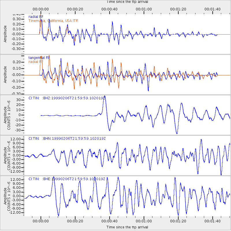
| Radial Match: |
91.22214 % |
| Radial Bump: |
400 |
| Transverse Match: |
89.93278 % |
| Transverse Bump: |
400 |
| SOD ConfigId: |
3787 |
| Insert Time: |
2010-02-25 20:50:09.999 +0000 |
| GWidth: |
2.5 |
| Max Bumps: |
400 |
| Tol: |
0.001 |
|
Signal To Noise
| Channel | StoN | STA | LTA |
| CI:TIN: :BHN:19990206T21:59:59.102019Z | 1.3251662 | 7.217599E-7 | 5.446561E-7 |
| CI:TIN: :BHE:19990206T21:59:59.102019Z | 0.9767798 | 5.7301094E-7 | 5.8663267E-7 |
| CI:TIN: :BHZ:19990206T21:59:59.102019Z | 4.398525 | 1.9587678E-6 | 4.4532374E-7 |
| Arrivals |
| Ps | 4.8 SECOND |
| PpPs | 15 SECOND |
| PsPs/PpSs | 20 SECOND |


