You are here: Home > Network List > WY - Yellowstone Wyoming Seismic Network Stations List
> Station YHH Holmes Hill, YNP, WY, USA > Earthquake Result Viewer
YHH Holmes Hill, YNP, WY, USA - Earthquake Result Viewer
| Earthquake location: |
Northern Chile |
| Earthquake latitude/longitude: |
-22.3/-68.6 |
| Earthquake time(UTC): |
2013/08/23 (235) 08:34:06 GMT |
| Earthquake Depth: |
111 km |
| Earthquake Magnitude: |
5.8 MWW, 5.7 MWD, 5.8 MWW, 5.8 MWB, 5.8 MWC |
| Earthquake Catalog/Contributor: |
NEIC PDE/NEIC COMCAT |
|
| Network: |
WY Yellowstone Wyoming Seismic Network |
| Station: |
YHH Holmes Hill, YNP, WY, USA |
| Lat/Lon: |
44.79 N/110.85 W |
| Elevation: |
2717 m |
|
| Distance: |
77.1 deg |
| Az: |
330.575 deg |
| Baz: |
140.278 deg |
| Ray Param: |
0.050303645 |
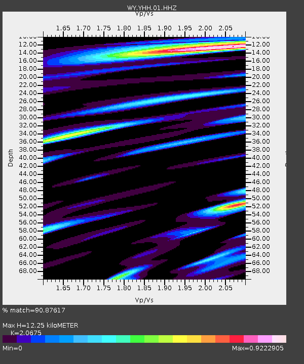
| Estimated Moho Depth: |
12.25 km |
| Estimated Crust Vp/Vs: |
2.07 |
| Assumed Crust Vp: |
6.35 km/s |
| Estimated Crust Vs: |
3.071 km/s |
| Estimated Crust Poisson's Ratio: |
0.35 |
|
| Radial Match: |
90.87617 % |
| Radial Bump: |
361 |
| Transverse Match: |
87.15752 % |
| Transverse Bump: |
400 |
| SOD ConfigId: |
626651 |
| Insert Time: |
2014-04-18 03:07:05.397 +0000 |
| GWidth: |
2.5 |
| Max Bumps: |
400 |
| Tol: |
0.001 |
|
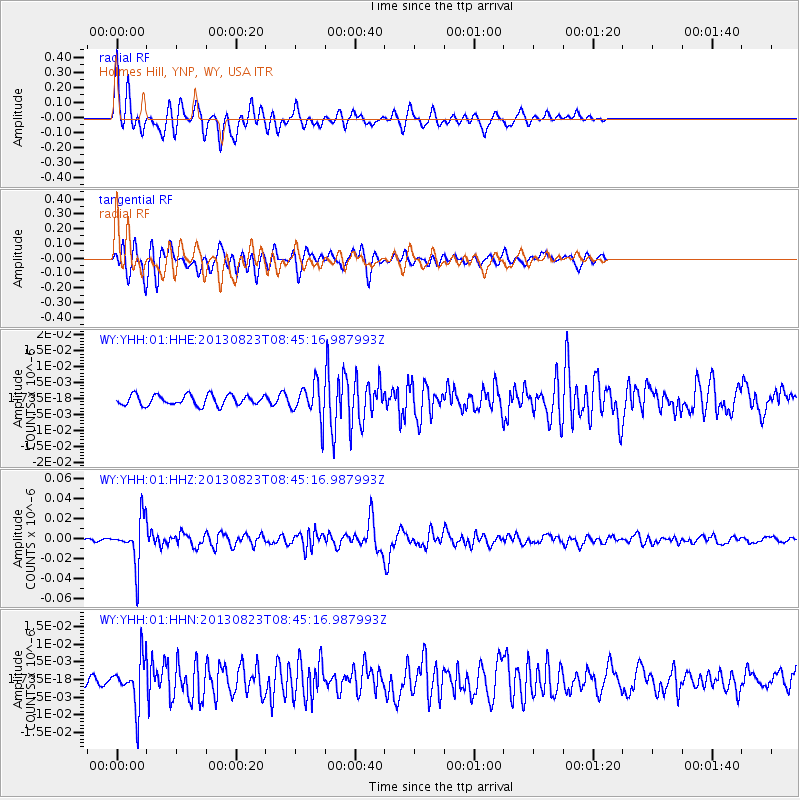
Signal To Noise
| Channel | StoN | STA | LTA |
| WY:YHH:01:HHZ:20130823T08:45:16.987993Z | 22.373734 | 2.2514714E-8 | 1.0063012E-9 |
| WY:YHH:01:HHN:20130823T08:45:16.987993Z | 5.9022584 | 6.598822E-9 | 1.1180165E-9 |
| WY:YHH:01:HHE:20130823T08:45:16.987993Z | 3.3267825 | 5.3512403E-9 | 1.6085332E-9 |
| Arrivals |
| Ps | 2.1 SECOND |
| PpPs | 5.8 SECOND |
| PsPs/PpSs | 7.9 SECOND |


