You are here: Home > Network List > BK - Berkeley Digital Seismograph Network Stations List
> Station HUMO Hull Mountain, OR > Earthquake Result Viewer
HUMO Hull Mountain, OR - Earthquake Result Viewer
| Earthquake location: |
Tonga Islands Region |
| Earthquake latitude/longitude: |
-22.5/-175.2 |
| Earthquake time(UTC): |
2013/08/24 (236) 08:40:28 GMT |
| Earthquake Depth: |
5.0 km |
| Earthquake Magnitude: |
5.8 MWW, 5.7 MWC, 5.8 MWW, 5.8 MWB |
| Earthquake Catalog/Contributor: |
NEIC PDE/NEIC COMCAT |
|
| Network: |
BK Berkeley Digital Seismograph Network |
| Station: |
HUMO Hull Mountain, OR |
| Lat/Lon: |
42.61 N/122.96 W |
| Elevation: |
555 m |
|
| Distance: |
80.7 deg |
| Az: |
36.279 deg |
| Baz: |
227.826 deg |
| Ray Param: |
0.048074666 |
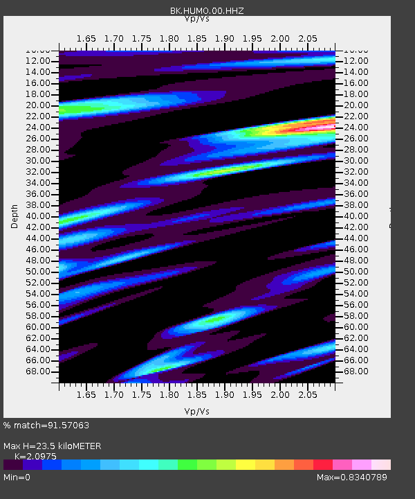
| Estimated Moho Depth: |
23.5 km |
| Estimated Crust Vp/Vs: |
2.10 |
| Assumed Crust Vp: |
6.522 km/s |
| Estimated Crust Vs: |
3.109 km/s |
| Estimated Crust Poisson's Ratio: |
0.35 |
|
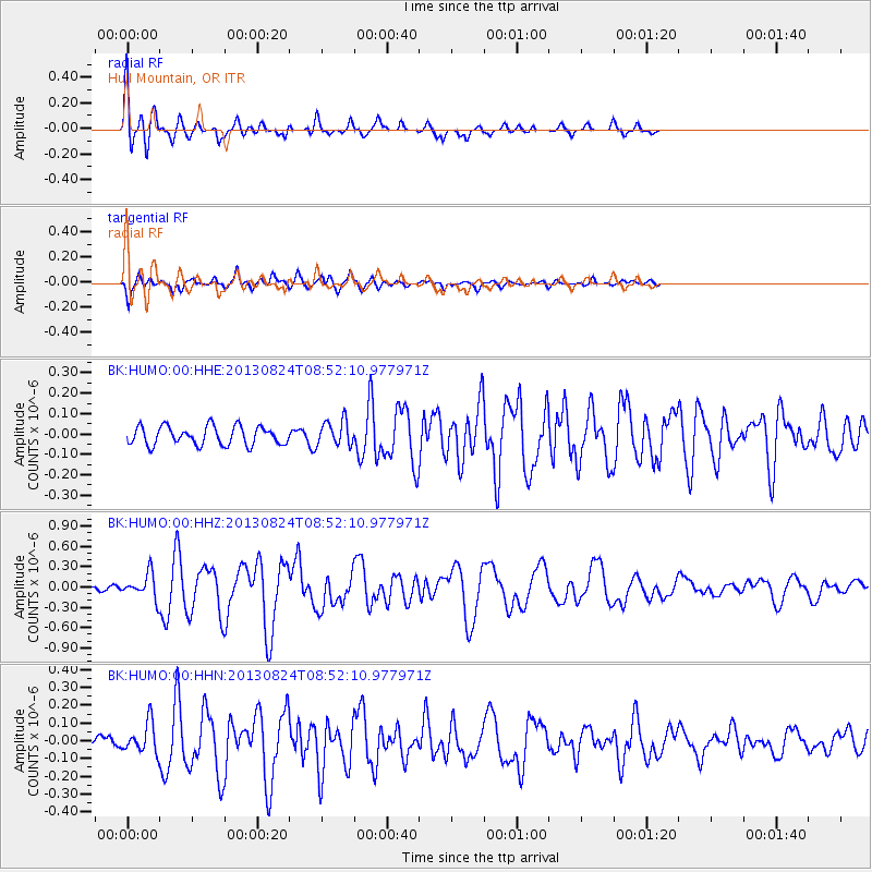
| Radial Match: |
91.57063 % |
| Radial Bump: |
400 |
| Transverse Match: |
82.46431 % |
| Transverse Bump: |
400 |
| SOD ConfigId: |
626651 |
| Insert Time: |
2014-04-18 03:16:24.747 +0000 |
| GWidth: |
2.5 |
| Max Bumps: |
400 |
| Tol: |
0.001 |
|
Signal To Noise
| Channel | StoN | STA | LTA |
| BK:HUMO:00:HHZ:20130824T08:52:10.977971Z | 3.55027 | 1.8096031E-7 | 5.097086E-8 |
| BK:HUMO:00:HHN:20130824T08:52:10.977971Z | 2.8795574 | 8.508255E-8 | 2.9547092E-8 |
| BK:HUMO:00:HHE:20130824T08:52:10.977971Z | 1.3723501 | 6.2277344E-8 | 4.538007E-8 |
| Arrivals |
| Ps | 4.1 SECOND |
| PpPs | 11 SECOND |
| PsPs/PpSs | 15 SECOND |


