You are here: Home > Network List > CB - China National Seismic Network Stations List
> Station CN2 Changchun,Jilin Province > Earthquake Result Viewer
CN2 Changchun,Jilin Province - Earthquake Result Viewer
| Earthquake location: |
Tonga Islands Region |
| Earthquake latitude/longitude: |
-22.5/-175.2 |
| Earthquake time(UTC): |
2013/08/24 (236) 08:40:28 GMT |
| Earthquake Depth: |
5.0 km |
| Earthquake Magnitude: |
5.8 MWW, 5.7 MWC, 5.8 MWW, 5.8 MWB |
| Earthquake Catalog/Contributor: |
NEIC PDE/NEIC COMCAT |
|
| Network: |
CB China National Seismic Network |
| Station: |
CN2 Changchun,Jilin Province |
| Lat/Lon: |
43.48 N/125.26 E |
| Elevation: |
223 m |
|
| Distance: |
85.4 deg |
| Az: |
321.007 deg |
| Baz: |
126.937 deg |
| Ray Param: |
0.044814486 |
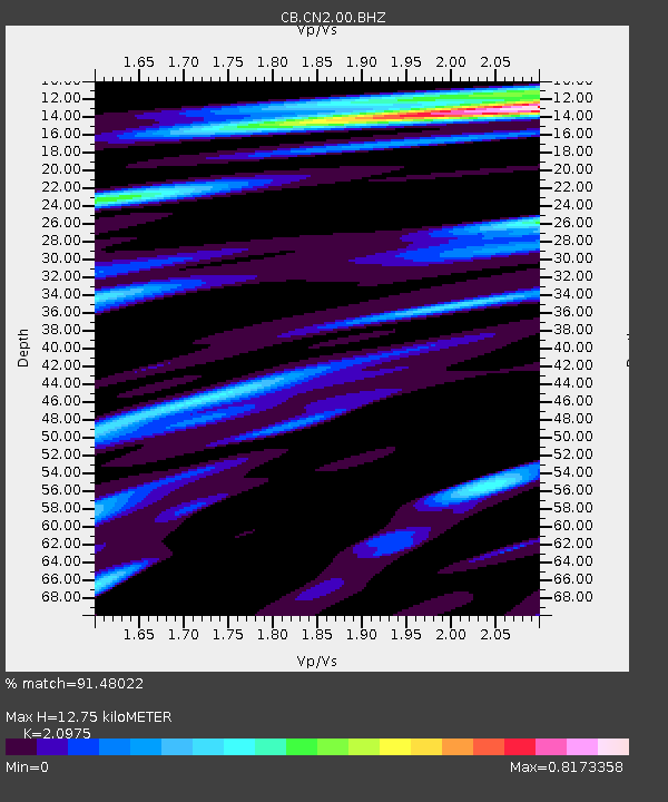
| Estimated Moho Depth: |
12.75 km |
| Estimated Crust Vp/Vs: |
2.10 |
| Assumed Crust Vp: |
6.459 km/s |
| Estimated Crust Vs: |
3.08 km/s |
| Estimated Crust Poisson's Ratio: |
0.35 |
|
| Radial Match: |
91.48022 % |
| Radial Bump: |
389 |
| Transverse Match: |
78.10331 % |
| Transverse Bump: |
400 |
| SOD ConfigId: |
626651 |
| Insert Time: |
2014-04-18 03:16:52.456 +0000 |
| GWidth: |
2.5 |
| Max Bumps: |
400 |
| Tol: |
0.001 |
|

Signal To Noise
| Channel | StoN | STA | LTA |
| CB:CN2:00:BHZ:20130824T08:52:34.830022Z | 9.926126 | 9.586566E-7 | 9.6579136E-8 |
| CB:CN2:00:BHN:20130824T08:52:34.830022Z | 2.9426854 | 2.0954677E-7 | 7.120937E-8 |
| CB:CN2:00:BHE:20130824T08:52:34.830022Z | 3.0148175 | 2.9665833E-7 | 9.84001E-8 |
| Arrivals |
| Ps | 2.2 SECOND |
| PpPs | 6.0 SECOND |
| PsPs/PpSs | 8.2 SECOND |


