You are here: Home > Network List > TA - USArray Transportable Network (new EarthScope stations) Stations List
> Station M04C Macdoel, CA, USA > Earthquake Result Viewer
M04C Macdoel, CA, USA - Earthquake Result Viewer

| Earthquake location: |
Tonga Islands Region |
| Earthquake latitude/longitude: |
-22.5/-175.2 |
| Earthquake time(UTC): |
2013/08/24 (236) 08:40:28 GMT |
| Earthquake Depth: |
5.0 km |
| Earthquake Magnitude: |
5.8 MWW, 5.7 MWC, 5.8 MWW, 5.8 MWB |
| Earthquake Catalog/Contributor: |
NEIC PDE/NEIC COMCAT |
|
| Network: |
TA USArray Transportable Network (new EarthScope stations) |
| Station: |
M04C Macdoel, CA, USA |
| Lat/Lon: |
41.78 N/121.84 W |
| Elevation: |
1391 m |
|
| Distance: |
80.8 deg |
| Az: |
37.462 deg |
| Baz: |
228.763 deg |
| Ray Param: |
0.048026264 |
| Estimated Moho Depth: |
10.25 km |
| Estimated Crust Vp/Vs: |
1.84 |
| Assumed Crust Vp: |
6.566 km/s |
| Estimated Crust Vs: |
3.578 km/s |
| Estimated Crust Poisson's Ratio: |
0.29 |
|
| Radial Match: |
85.27124 % |
| Radial Bump: |
400 |
| Transverse Match: |
69.61005 % |
| Transverse Bump: |
400 |
| SOD ConfigId: |
626651 |
| Insert Time: |
2014-04-18 03:29:45.176 +0000 |
| GWidth: |
2.5 |
| Max Bumps: |
400 |
| Tol: |
0.001 |
|
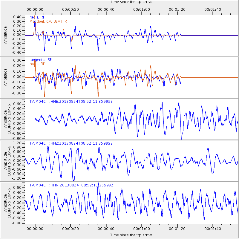
Signal To Noise
| Channel | StoN | STA | LTA |
| TA:M04C: :HHZ:20130824T08:52:11.35999Z | 4.4514046 | 2.3614653E-7 | 5.304989E-8 |
| TA:M04C: :HHN:20130824T08:52:11.35999Z | 2.1012363 | 2.0768678E-7 | 9.8840275E-8 |
| TA:M04C: :HHE:20130824T08:52:11.35999Z | 0.6453708 | 7.1936945E-8 | 1.1146608E-7 |
| Arrivals |
| Ps | 1.3 SECOND |
| PpPs | 4.3 SECOND |
| PsPs/PpSs | 5.6 SECOND |


