You are here: Home > Network List > UU - University of Utah Regional Network Stations List
> Station KNB Kanab, UT, USA > Earthquake Result Viewer
KNB Kanab, UT, USA - Earthquake Result Viewer
| Earthquake location: |
Tonga Islands Region |
| Earthquake latitude/longitude: |
-22.5/-175.2 |
| Earthquake time(UTC): |
2013/08/24 (236) 08:40:28 GMT |
| Earthquake Depth: |
5.0 km |
| Earthquake Magnitude: |
5.8 MWW, 5.7 MWC, 5.8 MWW, 5.8 MWB |
| Earthquake Catalog/Contributor: |
NEIC PDE/NEIC COMCAT |
|
| Network: |
UU University of Utah Regional Network |
| Station: |
KNB Kanab, UT, USA |
| Lat/Lon: |
37.02 N/112.82 W |
| Elevation: |
1715 m |
|
| Distance: |
83.4 deg |
| Az: |
45.572 deg |
| Baz: |
235.589 deg |
| Ray Param: |
0.046202112 |
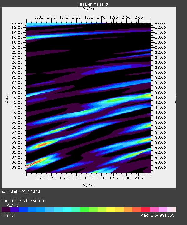
| Estimated Moho Depth: |
67.5 km |
| Estimated Crust Vp/Vs: |
1.60 |
| Assumed Crust Vp: |
6.194 km/s |
| Estimated Crust Vs: |
3.871 km/s |
| Estimated Crust Poisson's Ratio: |
0.18 |
|
| Radial Match: |
91.14686 % |
| Radial Bump: |
400 |
| Transverse Match: |
74.47479 % |
| Transverse Bump: |
400 |
| SOD ConfigId: |
626651 |
| Insert Time: |
2014-04-18 03:32:57.348 +0000 |
| GWidth: |
2.5 |
| Max Bumps: |
400 |
| Tol: |
0.001 |
|
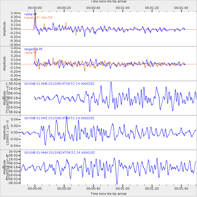
Signal To Noise
| Channel | StoN | STA | LTA |
| UU:KNB:01:HHZ:20130824T08:52:24.999028Z | 4.0108147 | 8.051008E-9 | 2.0073248E-9 |
| UU:KNB:01:HHN:20130824T08:52:24.999028Z | 0.94332534 | 2.045564E-9 | 2.1684607E-9 |
| UU:KNB:01:HHE:20130824T08:52:24.999028Z | 1.8089238 | 3.257567E-9 | 1.8008316E-9 |
| Arrivals |
| Ps | 6.7 SECOND |
| PpPs | 28 SECOND |
| PsPs/PpSs | 34 SECOND |


