You are here: Home > Network List > KN - Kyrgyz Seismic Telemetry Network Stations List
> Station TKM2 - > Earthquake Result Viewer
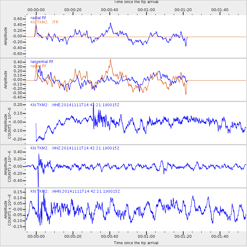
TKM2 - - Earthquake Result Viewer
*The percent match for this event was below the threshold and hence no stack was calculated.
| Earthquake location: |
Northwest Of Kuril Islands |
| Earthquake latitude/longitude: |
52.5/152.9 |
| Earthquake time(UTC): |
2014/11/11 (315) 14:34:40 GMT |
| Earthquake Depth: |
499 km |
| Earthquake Magnitude: |
4.7 mb, 4.8 mb |
| Earthquake Catalog/Contributor: |
ISC/ISC |
|
| Network: |
KN Kyrgyz Seismic Telemetry Network |
| Station: |
TKM2 - |
| Lat/Lon: |
42.92 N/75.60 E |
| Elevation: |
2020 m |
|
| Distance: |
50.6 deg |
| Az: |
291.85 deg |
| Baz: |
50.563 deg |
| Ray Param: |
$rayparam |
*The percent match for this event was below the threshold and hence was not used in the summary stack. |
|
| Radial Match: |
32.9509 % |
| Radial Bump: |
400 |
| Transverse Match: |
31.499071 % |
| Transverse Bump: |
400 |
| SOD ConfigId: |
3390531 |
| Insert Time: |
2019-04-14 22:49:48.482 +0000 |
| GWidth: |
2.5 |
| Max Bumps: |
400 |
| Tol: |
0.001 |
|
Signal To Noise
| Channel | StoN | STA | LTA |
| KN:TKM2: :HHZ:20141111T14:42:21.190015Z | 3.6676106 | 1.4740517E-7 | 4.0191065E-8 |
| KN:TKM2: :HHN:20141111T14:42:21.190015Z | 1.4079627 | 7.039932E-8 | 5.0000843E-8 |
| KN:TKM2: :HHE:20141111T14:42:21.190015Z | 1.2436593 | 1.0477525E-7 | 8.424756E-8 |
| Arrivals |
| Ps | |
| PpPs | |
| PsPs/PpSs | |


