You are here: Home > Network List > CN - Canadian National Seismograph Network Stations List
> Station LLLB LILLOOET, BC, CANADA ADA > Earthquake Result Viewer
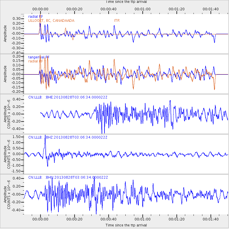
LLLB LILLOOET, BC, CANADA ADA - Earthquake Result Viewer
*The percent match for this event was below the threshold and hence no stack was calculated.
| Earthquake location: |
Kermadec Islands Region |
| Earthquake latitude/longitude: |
-27.8/179.6 |
| Earthquake time(UTC): |
2013/08/28 (240) 02:54:41 GMT |
| Earthquake Depth: |
478 km |
| Earthquake Magnitude: |
6.2 MWW, 6.2 MWW, 6.2 MWB, 6.2 MWC, 6.3 MWC |
| Earthquake Catalog/Contributor: |
NEIC PDE/NEIC COMCAT |
|
| Network: |
CN Canadian National Seismograph Network |
| Station: |
LLLB LILLOOET, BC, CANADA ADA |
| Lat/Lon: |
50.61 N/121.88 W |
| Elevation: |
700 m |
|
| Distance: |
93.6 deg |
| Az: |
32.972 deg |
| Baz: |
229.182 deg |
| Ray Param: |
$rayparam |
*The percent match for this event was below the threshold and hence was not used in the summary stack. |
|
| Radial Match: |
60.001175 % |
| Radial Bump: |
400 |
| Transverse Match: |
56.82323 % |
| Transverse Bump: |
400 |
| SOD ConfigId: |
626651 |
| Insert Time: |
2014-04-18 03:56:45.008 +0000 |
| GWidth: |
2.5 |
| Max Bumps: |
400 |
| Tol: |
0.001 |
|
Signal To Noise
| Channel | StoN | STA | LTA |
| CN:LLLB: :BHZ:20130828T03:06:34.000022Z | 5.744456 | 5.5904025E-7 | 9.731823E-8 |
| CN:LLLB: :BHN:20130828T03:06:34.000022Z | 1.5943354 | 1.2826014E-7 | 8.044739E-8 |
| CN:LLLB: :BHE:20130828T03:06:34.000022Z | 2.0298216 | 1.1897862E-7 | 5.8615306E-8 |
| Arrivals |
| Ps | |
| PpPs | |
| PsPs/PpSs | |


