You are here: Home > Network List > US - United States National Seismic Network Stations List
> Station ERPA Erie, Pennsylvania, USA > Earthquake Result Viewer
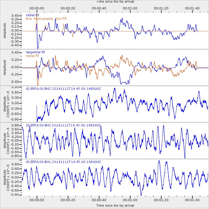
ERPA Erie, Pennsylvania, USA - Earthquake Result Viewer
*The percent match for this event was below the threshold and hence no stack was calculated.
| Earthquake location: |
Northwest Of Kuril Islands |
| Earthquake latitude/longitude: |
52.5/152.9 |
| Earthquake time(UTC): |
2014/11/11 (315) 14:34:40 GMT |
| Earthquake Depth: |
499 km |
| Earthquake Magnitude: |
4.7 mb, 4.8 mb |
| Earthquake Catalog/Contributor: |
ISC/ISC |
|
| Network: |
US United States National Seismic Network |
| Station: |
ERPA Erie, Pennsylvania, USA |
| Lat/Lon: |
42.12 N/79.99 W |
| Elevation: |
306 m |
|
| Distance: |
75.2 deg |
| Az: |
37.874 deg |
| Baz: |
329.711 deg |
| Ray Param: |
$rayparam |
*The percent match for this event was below the threshold and hence was not used in the summary stack. |
|
| Radial Match: |
56.939827 % |
| Radial Bump: |
400 |
| Transverse Match: |
38.91475 % |
| Transverse Bump: |
400 |
| SOD ConfigId: |
3390531 |
| Insert Time: |
2019-04-14 22:53:53.948 +0000 |
| GWidth: |
2.5 |
| Max Bumps: |
400 |
| Tol: |
0.001 |
|
Signal To Noise
| Channel | StoN | STA | LTA |
| US:ERPA:00:BHZ:20141111T14:45:00.148999Z | 0.6599782 | 2.2354703E-7 | 3.3871882E-7 |
| US:ERPA:00:BH1:20141111T14:45:00.148999Z | 0.9026977 | 2.4626237E-7 | 2.7280714E-7 |
| US:ERPA:00:BH2:20141111T14:45:00.148999Z | 0.94737464 | 3.6437592E-7 | 3.846165E-7 |
| Arrivals |
| Ps | |
| PpPs | |
| PsPs/PpSs | |


