You are here: Home > Network List > US - United States National Seismic Network Stations List
> Station MIAR Mount Ida, Arkansas, USA > Earthquake Result Viewer
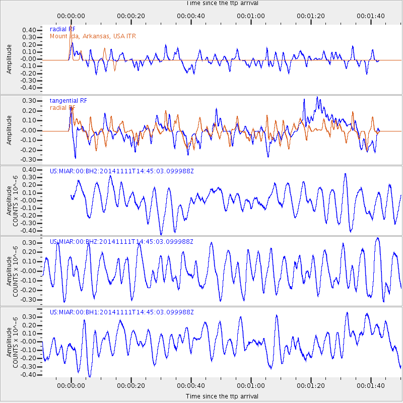
MIAR Mount Ida, Arkansas, USA - Earthquake Result Viewer
*The percent match for this event was below the threshold and hence no stack was calculated.
| Earthquake location: |
Northwest Of Kuril Islands |
| Earthquake latitude/longitude: |
52.5/152.9 |
| Earthquake time(UTC): |
2014/11/11 (315) 14:34:40 GMT |
| Earthquake Depth: |
499 km |
| Earthquake Magnitude: |
4.7 mb, 4.8 mb |
| Earthquake Catalog/Contributor: |
ISC/ISC |
|
| Network: |
US United States National Seismic Network |
| Station: |
MIAR Mount Ida, Arkansas, USA |
| Lat/Lon: |
34.55 N/93.58 W |
| Elevation: |
207 m |
|
| Distance: |
75.8 deg |
| Az: |
51.357 deg |
| Baz: |
324.664 deg |
| Ray Param: |
$rayparam |
*The percent match for this event was below the threshold and hence was not used in the summary stack. |
|
| Radial Match: |
43.49193 % |
| Radial Bump: |
400 |
| Transverse Match: |
39.2215 % |
| Transverse Bump: |
400 |
| SOD ConfigId: |
3390531 |
| Insert Time: |
2019-04-14 22:53:58.463 +0000 |
| GWidth: |
2.5 |
| Max Bumps: |
400 |
| Tol: |
0.001 |
|
Signal To Noise
| Channel | StoN | STA | LTA |
| US:MIAR:00:BHZ:20141111T14:45:03.099988Z | 0.67304605 | 1.06718666E-7 | 1.5856072E-7 |
| US:MIAR:00:BH1:20141111T14:45:03.099988Z | 1.6345114 | 2.337664E-7 | 1.4301914E-7 |
| US:MIAR:00:BH2:20141111T14:45:03.099988Z | 2.3097582 | 2.9954973E-7 | 1.2968877E-7 |
| Arrivals |
| Ps | |
| PpPs | |
| PsPs/PpSs | |


