You are here: Home > Network List > IU - Global Seismograph Network (GSN - IRIS/USGS) Stations List
> Station MAJO Matsushiro, Japan > Earthquake Result Viewer
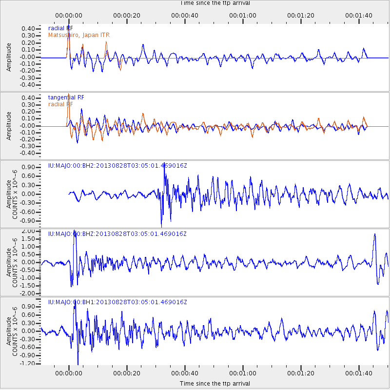
MAJO Matsushiro, Japan - Earthquake Result Viewer
*The percent match for this event was below the threshold and hence no stack was calculated.
| Earthquake location: |
Kermadec Islands Region |
| Earthquake latitude/longitude: |
-27.8/179.6 |
| Earthquake time(UTC): |
2013/08/28 (240) 02:54:41 GMT |
| Earthquake Depth: |
478 km |
| Earthquake Magnitude: |
6.2 MWW, 6.2 MWW, 6.2 MWB, 6.2 MWC, 6.3 MWC |
| Earthquake Catalog/Contributor: |
NEIC PDE/NEIC COMCAT |
|
| Network: |
IU Global Seismograph Network (GSN - IRIS/USGS) |
| Station: |
MAJO Matsushiro, Japan |
| Lat/Lon: |
36.55 N/138.20 E |
| Elevation: |
405 m |
|
| Distance: |
74.9 deg |
| Az: |
326.506 deg |
| Baz: |
142.616 deg |
| Ray Param: |
$rayparam |
*The percent match for this event was below the threshold and hence was not used in the summary stack. |
|
| Radial Match: |
71.696846 % |
| Radial Bump: |
400 |
| Transverse Match: |
70.329575 % |
| Transverse Bump: |
392 |
| SOD ConfigId: |
626651 |
| Insert Time: |
2014-04-18 04:00:25.282 +0000 |
| GWidth: |
2.5 |
| Max Bumps: |
400 |
| Tol: |
0.001 |
|
Signal To Noise
| Channel | StoN | STA | LTA |
| IU:MAJO:00:BHZ:20130828T03:05:01.469016Z | 11.46169 | 9.535851E-7 | 8.31976E-8 |
| IU:MAJO:00:BH1:20130828T03:05:01.469016Z | 5.4543347 | 4.8070285E-7 | 8.813227E-8 |
| IU:MAJO:00:BH2:20130828T03:05:01.469016Z | 4.7848682 | 3.9971988E-7 | 8.3538325E-8 |
| Arrivals |
| Ps | |
| PpPs | |
| PsPs/PpSs | |


