You are here: Home > Network List > TA - USArray Transportable Network (new EarthScope stations) Stations List
> Station G05D Wamic, OR, USA > Earthquake Result Viewer
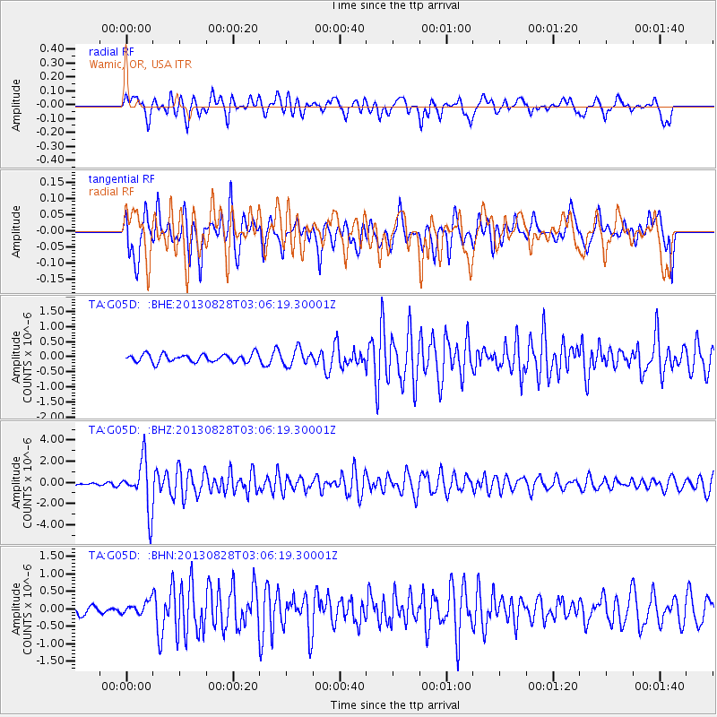
G05D Wamic, OR, USA - Earthquake Result Viewer
*The percent match for this event was below the threshold and hence no stack was calculated.
| Earthquake location: |
Kermadec Islands Region |
| Earthquake latitude/longitude: |
-27.8/179.6 |
| Earthquake time(UTC): |
2013/08/28 (240) 02:54:41 GMT |
| Earthquake Depth: |
478 km |
| Earthquake Magnitude: |
6.2 MWW, 6.2 MWW, 6.2 MWB, 6.2 MWC, 6.3 MWC |
| Earthquake Catalog/Contributor: |
NEIC PDE/NEIC COMCAT |
|
| Network: |
TA USArray Transportable Network (new EarthScope stations) |
| Station: |
G05D Wamic, OR, USA |
| Lat/Lon: |
45.24 N/121.32 W |
| Elevation: |
592 m |
|
| Distance: |
90.4 deg |
| Az: |
37.294 deg |
| Baz: |
229.452 deg |
| Ray Param: |
$rayparam |
*The percent match for this event was below the threshold and hence was not used in the summary stack. |
|
| Radial Match: |
64.29592 % |
| Radial Bump: |
400 |
| Transverse Match: |
71.505905 % |
| Transverse Bump: |
400 |
| SOD ConfigId: |
626651 |
| Insert Time: |
2014-04-18 04:06:11.632 +0000 |
| GWidth: |
2.5 |
| Max Bumps: |
400 |
| Tol: |
0.001 |
|
Signal To Noise
| Channel | StoN | STA | LTA |
| TA:G05D: :BHZ:20130828T03:06:19.30001Z | 13.033605 | 2.379289E-6 | 1.8255034E-7 |
| TA:G05D: :BHN:20130828T03:06:19.30001Z | 1.0337008 | 1.7678673E-7 | 1.7102312E-7 |
| TA:G05D: :BHE:20130828T03:06:19.30001Z | 2.0150888 | 2.652408E-7 | 1.3162736E-7 |
| Arrivals |
| Ps | |
| PpPs | |
| PsPs/PpSs | |


