You are here: Home > Network List > TA - USArray Transportable Network (new EarthScope stations) Stations List
> Station T25A Trinidad, CO, USA > Earthquake Result Viewer
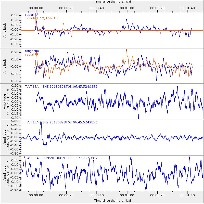
T25A Trinidad, CO, USA - Earthquake Result Viewer
*The percent match for this event was below the threshold and hence no stack was calculated.
| Earthquake location: |
Kermadec Islands Region |
| Earthquake latitude/longitude: |
-27.8/179.6 |
| Earthquake time(UTC): |
2013/08/28 (240) 02:54:41 GMT |
| Earthquake Depth: |
478 km |
| Earthquake Magnitude: |
6.2 MWW, 6.2 MWW, 6.2 MWB, 6.2 MWC, 6.3 MWC |
| Earthquake Catalog/Contributor: |
NEIC PDE/NEIC COMCAT |
|
| Network: |
TA USArray Transportable Network (new EarthScope stations) |
| Station: |
T25A Trinidad, CO, USA |
| Lat/Lon: |
37.14 N/104.41 W |
| Elevation: |
2017 m |
|
| Distance: |
96.1 deg |
| Az: |
51.234 deg |
| Baz: |
239.823 deg |
| Ray Param: |
$rayparam |
*The percent match for this event was below the threshold and hence was not used in the summary stack. |
|
| Radial Match: |
63.550316 % |
| Radial Bump: |
400 |
| Transverse Match: |
46.777954 % |
| Transverse Bump: |
400 |
| SOD ConfigId: |
626651 |
| Insert Time: |
2014-04-18 04:07:42.133 +0000 |
| GWidth: |
2.5 |
| Max Bumps: |
400 |
| Tol: |
0.001 |
|
Signal To Noise
| Channel | StoN | STA | LTA |
| TA:T25A: :BHZ:20130828T03:06:45.524985Z | 7.61814 | 3.3207263E-7 | 4.3589722E-8 |
| TA:T25A: :BHN:20130828T03:06:45.524985Z | 1.0059276 | 6.824105E-8 | 6.7838926E-8 |
| TA:T25A: :BHE:20130828T03:06:45.524985Z | 1.119039 | 5.7034832E-8 | 5.096769E-8 |
| Arrivals |
| Ps | |
| PpPs | |
| PsPs/PpSs | |


