You are here: Home > Network List > BK - Berkeley Digital Seismograph Network Stations List
> Station HUMO Hull Mountain, OR > Earthquake Result Viewer
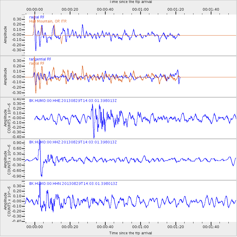
HUMO Hull Mountain, OR - Earthquake Result Viewer
*The percent match for this event was below the threshold and hence no stack was calculated.
| Earthquake location: |
Fiji Islands Region |
| Earthquake latitude/longitude: |
-19.4/-179.1 |
| Earthquake time(UTC): |
2013/08/29 (241) 13:52:27 GMT |
| Earthquake Depth: |
662 km |
| Earthquake Magnitude: |
5.7 MWW, 5.7 MWW, 5.8 MWC, 5.8 MWB |
| Earthquake Catalog/Contributor: |
NEIC PDE/NEIC COMCAT |
|
| Network: |
BK Berkeley Digital Seismograph Network |
| Station: |
HUMO Hull Mountain, OR |
| Lat/Lon: |
42.61 N/122.96 W |
| Elevation: |
555 m |
|
| Distance: |
80.5 deg |
| Az: |
38.459 deg |
| Baz: |
232.697 deg |
| Ray Param: |
$rayparam |
*The percent match for this event was below the threshold and hence was not used in the summary stack. |
|
| Radial Match: |
78.22941 % |
| Radial Bump: |
400 |
| Transverse Match: |
49.206535 % |
| Transverse Bump: |
396 |
| SOD ConfigId: |
626651 |
| Insert Time: |
2014-04-18 04:19:39.154 +0000 |
| GWidth: |
2.5 |
| Max Bumps: |
400 |
| Tol: |
0.001 |
|
Signal To Noise
| Channel | StoN | STA | LTA |
| BK:HUMO:00:HHZ:20130829T14:03:01.398013Z | 10.952715 | 4.7869463E-7 | 4.370557E-8 |
| BK:HUMO:00:HHN:20130829T14:03:01.398013Z | 2.1536 | 1.16611524E-7 | 5.4147254E-8 |
| BK:HUMO:00:HHE:20130829T14:03:01.398013Z | 3.3764122 | 1.6585825E-7 | 4.9122633E-8 |
| Arrivals |
| Ps | |
| PpPs | |
| PsPs/PpSs | |


