You are here: Home > Network List > TA - USArray Transportable Network (new EarthScope stations) Stations List
> Station G05D Wamic, OR, USA > Earthquake Result Viewer
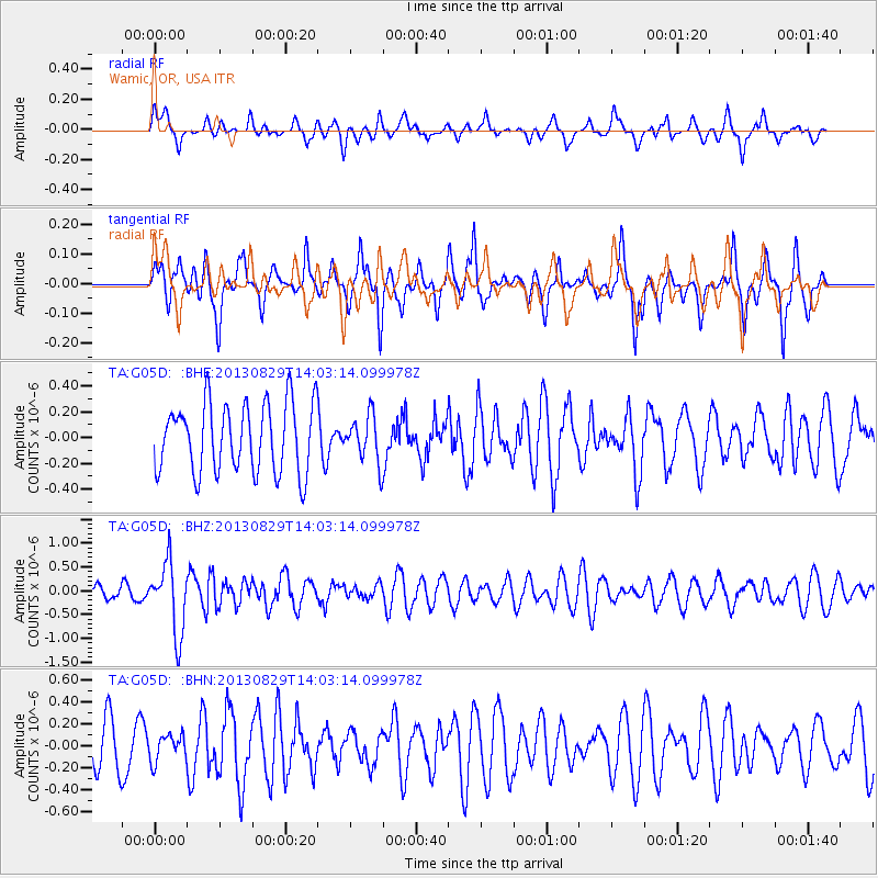
G05D Wamic, OR, USA - Earthquake Result Viewer
*The percent match for this event was below the threshold and hence no stack was calculated.
| Earthquake location: |
Fiji Islands Region |
| Earthquake latitude/longitude: |
-19.4/-179.1 |
| Earthquake time(UTC): |
2013/08/29 (241) 13:52:27 GMT |
| Earthquake Depth: |
662 km |
| Earthquake Magnitude: |
5.7 MWW, 5.7 MWW, 5.8 MWC, 5.8 MWB |
| Earthquake Catalog/Contributor: |
NEIC PDE/NEIC COMCAT |
|
| Network: |
TA USArray Transportable Network (new EarthScope stations) |
| Station: |
G05D Wamic, OR, USA |
| Lat/Lon: |
45.24 N/121.32 W |
| Elevation: |
592 m |
|
| Distance: |
83.0 deg |
| Az: |
37.047 deg |
| Baz: |
233.628 deg |
| Ray Param: |
$rayparam |
*The percent match for this event was below the threshold and hence was not used in the summary stack. |
|
| Radial Match: |
44.907715 % |
| Radial Bump: |
400 |
| Transverse Match: |
61.664463 % |
| Transverse Bump: |
325 |
| SOD ConfigId: |
626651 |
| Insert Time: |
2014-04-18 04:27:34.463 +0000 |
| GWidth: |
2.5 |
| Max Bumps: |
400 |
| Tol: |
0.001 |
|
Signal To Noise
| Channel | StoN | STA | LTA |
| TA:G05D: :BHZ:20130829T14:03:14.099978Z | 4.2132387 | 7.3856876E-7 | 1.7529715E-7 |
| TA:G05D: :BHN:20130829T14:03:14.099978Z | 0.69979763 | 1.2009495E-7 | 1.7161383E-7 |
| TA:G05D: :BHE:20130829T14:03:14.099978Z | 0.672276 | 1.803825E-7 | 2.6831614E-7 |
| Arrivals |
| Ps | |
| PpPs | |
| PsPs/PpSs | |


