You are here: Home > Network List > US - United States National Seismic Network Stations List
> Station ELK Elko, Nevada, USA > Earthquake Result Viewer
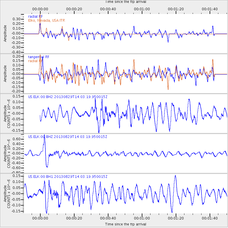
ELK Elko, Nevada, USA - Earthquake Result Viewer
*The percent match for this event was below the threshold and hence no stack was calculated.
| Earthquake location: |
Fiji Islands Region |
| Earthquake latitude/longitude: |
-19.4/-179.1 |
| Earthquake time(UTC): |
2013/08/29 (241) 13:52:27 GMT |
| Earthquake Depth: |
662 km |
| Earthquake Magnitude: |
5.7 MWW, 5.7 MWW, 5.8 MWC, 5.8 MWB |
| Earthquake Catalog/Contributor: |
NEIC PDE/NEIC COMCAT |
|
| Network: |
US United States National Seismic Network |
| Station: |
ELK Elko, Nevada, USA |
| Lat/Lon: |
40.74 N/115.24 W |
| Elevation: |
2210 m |
|
| Distance: |
84.2 deg |
| Az: |
43.301 deg |
| Baz: |
238.463 deg |
| Ray Param: |
$rayparam |
*The percent match for this event was below the threshold and hence was not used in the summary stack. |
|
| Radial Match: |
68.472176 % |
| Radial Bump: |
400 |
| Transverse Match: |
60.35015 % |
| Transverse Bump: |
400 |
| SOD ConfigId: |
626651 |
| Insert Time: |
2014-04-18 04:29:37.705 +0000 |
| GWidth: |
2.5 |
| Max Bumps: |
400 |
| Tol: |
0.001 |
|
Signal To Noise
| Channel | StoN | STA | LTA |
| US:ELK:00:BHZ:20130829T14:03:19.950015Z | 6.6340485 | 3.6432394E-7 | 5.4917283E-8 |
| US:ELK:00:BH1:20130829T14:03:19.950015Z | 1.5307229 | 7.728901E-8 | 5.049184E-8 |
| US:ELK:00:BH2:20130829T14:03:19.950015Z | 1.8756571 | 7.113577E-8 | 3.7925787E-8 |
| Arrivals |
| Ps | |
| PpPs | |
| PsPs/PpSs | |


