You are here: Home > Network List > US - United States National Seismic Network Stations List
> Station MNTX Cornudas Mountains, Texas, USA > Earthquake Result Viewer
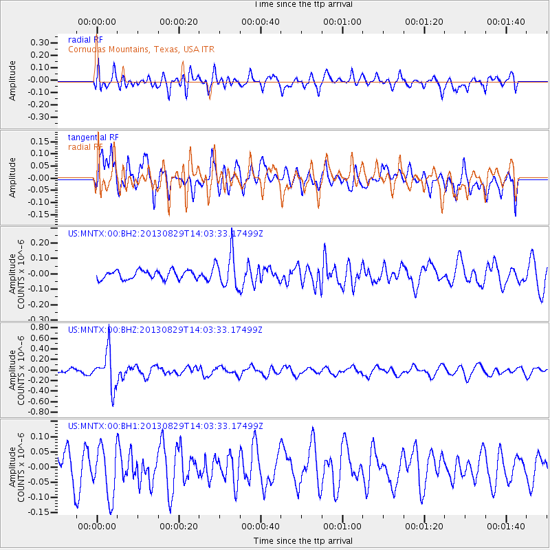
MNTX Cornudas Mountains, Texas, USA - Earthquake Result Viewer
*The percent match for this event was below the threshold and hence no stack was calculated.
| Earthquake location: |
Fiji Islands Region |
| Earthquake latitude/longitude: |
-19.4/-179.1 |
| Earthquake time(UTC): |
2013/08/29 (241) 13:52:27 GMT |
| Earthquake Depth: |
662 km |
| Earthquake Magnitude: |
5.7 MWW, 5.7 MWW, 5.8 MWC, 5.8 MWB |
| Earthquake Catalog/Contributor: |
NEIC PDE/NEIC COMCAT |
|
| Network: |
US United States National Seismic Network |
| Station: |
MNTX Cornudas Mountains, Texas, USA |
| Lat/Lon: |
31.70 N/105.38 W |
| Elevation: |
404 m |
|
| Distance: |
87.0 deg |
| Az: |
55.036 deg |
| Baz: |
245.199 deg |
| Ray Param: |
$rayparam |
*The percent match for this event was below the threshold and hence was not used in the summary stack. |
|
| Radial Match: |
52.556797 % |
| Radial Bump: |
400 |
| Transverse Match: |
54.035473 % |
| Transverse Bump: |
392 |
| SOD ConfigId: |
626651 |
| Insert Time: |
2014-04-18 04:29:53.740 +0000 |
| GWidth: |
2.5 |
| Max Bumps: |
400 |
| Tol: |
0.001 |
|
Signal To Noise
| Channel | StoN | STA | LTA |
| US:MNTX:00:BHZ:20130829T14:03:33.17499Z | 6.8014593 | 3.5912623E-7 | 5.2801347E-8 |
| US:MNTX:00:BH1:20130829T14:03:33.17499Z | 1.3761569 | 8.602337E-8 | 6.2509855E-8 |
| US:MNTX:00:BH2:20130829T14:03:33.17499Z | 4.015737 | 1.1082846E-7 | 2.7598533E-8 |
| Arrivals |
| Ps | |
| PpPs | |
| PsPs/PpSs | |


