You are here: Home > Network List > US - United States National Seismic Network Stations List
> Station MSO Missoula, Montana, USA > Earthquake Result Viewer
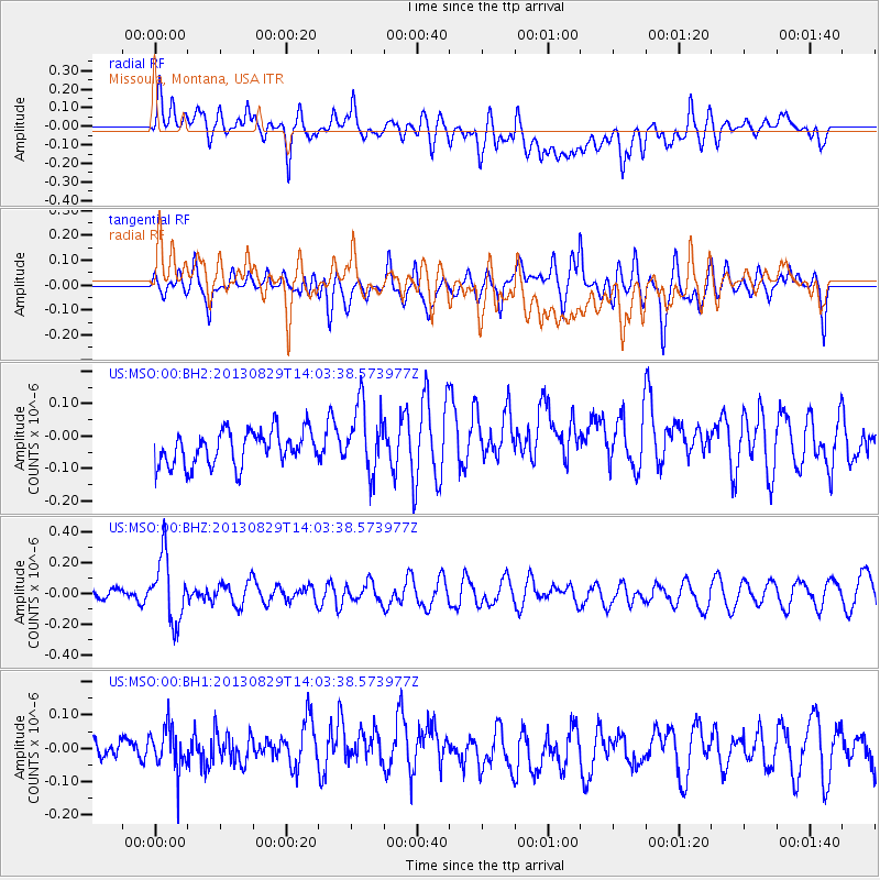
MSO Missoula, Montana, USA - Earthquake Result Viewer
*The percent match for this event was below the threshold and hence no stack was calculated.
| Earthquake location: |
Fiji Islands Region |
| Earthquake latitude/longitude: |
-19.4/-179.1 |
| Earthquake time(UTC): |
2013/08/29 (241) 13:52:27 GMT |
| Earthquake Depth: |
662 km |
| Earthquake Magnitude: |
5.7 MWW, 5.7 MWW, 5.8 MWC, 5.8 MWB |
| Earthquake Catalog/Contributor: |
NEIC PDE/NEIC COMCAT |
|
| Network: |
US United States National Seismic Network |
| Station: |
MSO Missoula, Montana, USA |
| Lat/Lon: |
46.83 N/113.94 W |
| Elevation: |
1264 m |
|
| Distance: |
88.1 deg |
| Az: |
38.58 deg |
| Baz: |
239.042 deg |
| Ray Param: |
$rayparam |
*The percent match for this event was below the threshold and hence was not used in the summary stack. |
|
| Radial Match: |
49.370705 % |
| Radial Bump: |
400 |
| Transverse Match: |
48.522163 % |
| Transverse Bump: |
400 |
| SOD ConfigId: |
626651 |
| Insert Time: |
2014-04-18 04:29:55.942 +0000 |
| GWidth: |
2.5 |
| Max Bumps: |
400 |
| Tol: |
0.001 |
|
Signal To Noise
| Channel | StoN | STA | LTA |
| US:MSO:00:BHZ:20130829T14:03:38.573977Z | 4.2764177 | 2.1063828E-7 | 4.9255775E-8 |
| US:MSO:00:BH1:20130829T14:03:38.573977Z | 1.4534565 | 7.272968E-8 | 5.0039116E-8 |
| US:MSO:00:BH2:20130829T14:03:38.573977Z | 1.9830668 | 1.0543958E-7 | 5.3169963E-8 |
| Arrivals |
| Ps | |
| PpPs | |
| PsPs/PpSs | |


