You are here: Home > Network List > US - United States National Seismic Network Stations List
> Station NEW Newport, Washington, USA > Earthquake Result Viewer
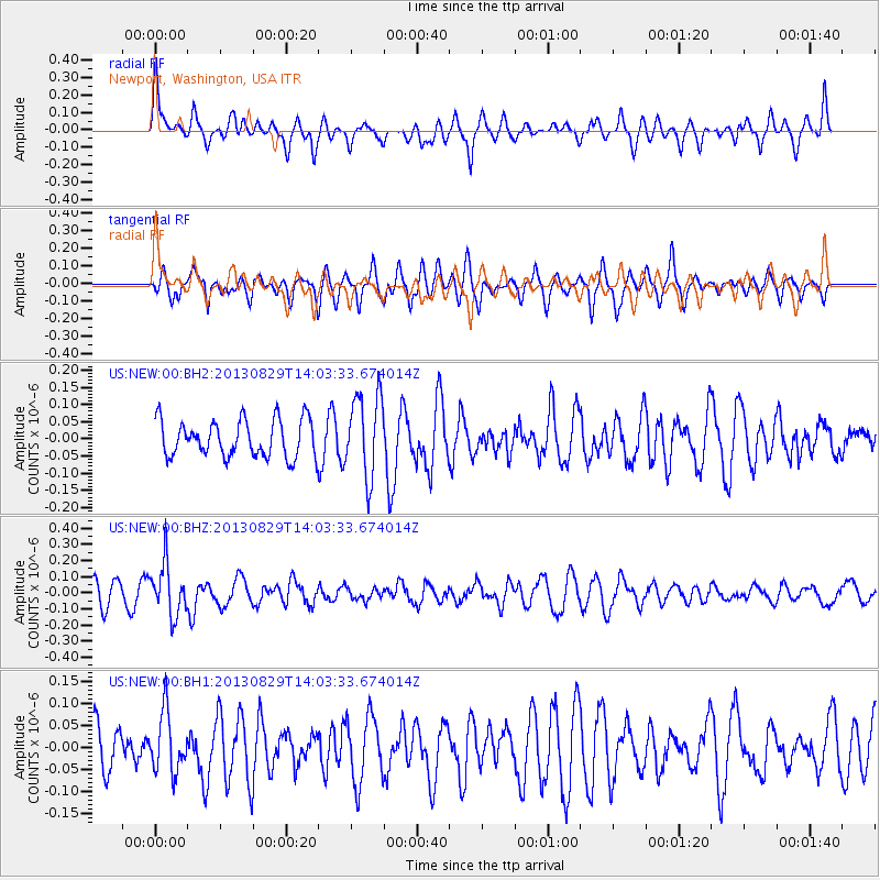
NEW Newport, Washington, USA - Earthquake Result Viewer
*The percent match for this event was below the threshold and hence no stack was calculated.
| Earthquake location: |
Fiji Islands Region |
| Earthquake latitude/longitude: |
-19.4/-179.1 |
| Earthquake time(UTC): |
2013/08/29 (241) 13:52:27 GMT |
| Earthquake Depth: |
662 km |
| Earthquake Magnitude: |
5.7 MWW, 5.7 MWW, 5.8 MWC, 5.8 MWB |
| Earthquake Catalog/Contributor: |
NEIC PDE/NEIC COMCAT |
|
| Network: |
US United States National Seismic Network |
| Station: |
NEW Newport, Washington, USA |
| Lat/Lon: |
48.26 N/117.12 W |
| Elevation: |
760 m |
|
| Distance: |
87.1 deg |
| Az: |
36.216 deg |
| Baz: |
236.605 deg |
| Ray Param: |
$rayparam |
*The percent match for this event was below the threshold and hence was not used in the summary stack. |
|
| Radial Match: |
50.375553 % |
| Radial Bump: |
349 |
| Transverse Match: |
50.16266 % |
| Transverse Bump: |
348 |
| SOD ConfigId: |
626651 |
| Insert Time: |
2014-04-18 04:30:02.162 +0000 |
| GWidth: |
2.5 |
| Max Bumps: |
400 |
| Tol: |
0.001 |
|
Signal To Noise
| Channel | StoN | STA | LTA |
| US:NEW:00:BHZ:20130829T14:03:33.674014Z | 2.2258337 | 1.5896343E-7 | 7.1417475E-8 |
| US:NEW:00:BH1:20130829T14:03:33.674014Z | 1.0958321 | 6.705994E-8 | 6.119546E-8 |
| US:NEW:00:BH2:20130829T14:03:33.674014Z | 2.230977 | 1.1916967E-7 | 5.341591E-8 |
| Arrivals |
| Ps | |
| PpPs | |
| PsPs/PpSs | |


