You are here: Home > Network List > UU - University of Utah Regional Network Stations List
> Station KNB Kanab, UT, USA > Earthquake Result Viewer
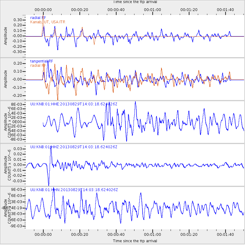
KNB Kanab, UT, USA - Earthquake Result Viewer
*The percent match for this event was below the threshold and hence no stack was calculated.
| Earthquake location: |
Fiji Islands Region |
| Earthquake latitude/longitude: |
-19.4/-179.1 |
| Earthquake time(UTC): |
2013/08/29 (241) 13:52:27 GMT |
| Earthquake Depth: |
662 km |
| Earthquake Magnitude: |
5.7 MWW, 5.7 MWW, 5.8 MWC, 5.8 MWB |
| Earthquake Catalog/Contributor: |
NEIC PDE/NEIC COMCAT |
|
| Network: |
UU University of Utah Regional Network |
| Station: |
KNB Kanab, UT, USA |
| Lat/Lon: |
37.02 N/112.82 W |
| Elevation: |
1715 m |
|
| Distance: |
83.9 deg |
| Az: |
47.488 deg |
| Baz: |
240.41 deg |
| Ray Param: |
$rayparam |
*The percent match for this event was below the threshold and hence was not used in the summary stack. |
|
| Radial Match: |
59.644596 % |
| Radial Bump: |
381 |
| Transverse Match: |
71.79907 % |
| Transverse Bump: |
400 |
| SOD ConfigId: |
626651 |
| Insert Time: |
2014-04-18 04:30:36.182 +0000 |
| GWidth: |
2.5 |
| Max Bumps: |
400 |
| Tol: |
0.001 |
|
Signal To Noise
| Channel | StoN | STA | LTA |
| UU:KNB:01:HHZ:20130829T14:03:18.624026Z | 7.173972 | 1.6595262E-8 | 2.3132598E-9 |
| UU:KNB:01:HHN:20130829T14:03:18.624026Z | 1.1361142 | 3.4526584E-9 | 3.0390064E-9 |
| UU:KNB:01:HHE:20130829T14:03:18.624026Z | 1.5984778 | 4.1035024E-9 | 2.5671312E-9 |
| Arrivals |
| Ps | |
| PpPs | |
| PsPs/PpSs | |


