You are here: Home > Network List > UW - Pacific Northwest Regional Seismic Network Stations List
> Station LEBA Lebam, WA, USA > Earthquake Result Viewer
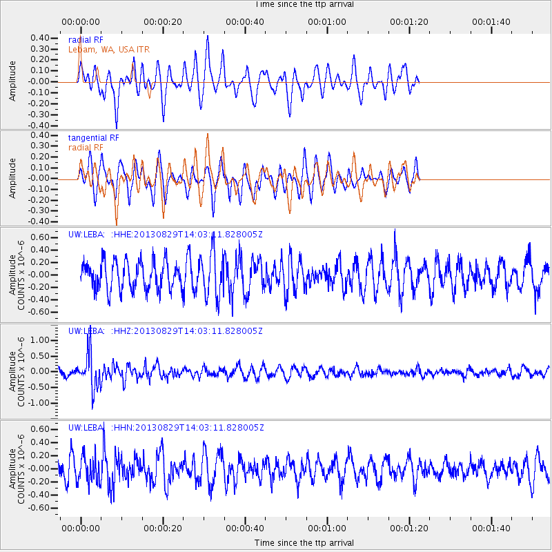
LEBA Lebam, WA, USA - Earthquake Result Viewer
*The percent match for this event was below the threshold and hence no stack was calculated.
| Earthquake location: |
Fiji Islands Region |
| Earthquake latitude/longitude: |
-19.4/-179.1 |
| Earthquake time(UTC): |
2013/08/29 (241) 13:52:27 GMT |
| Earthquake Depth: |
662 km |
| Earthquake Magnitude: |
5.7 MWW, 5.7 MWW, 5.8 MWC, 5.8 MWB |
| Earthquake Catalog/Contributor: |
NEIC PDE/NEIC COMCAT |
|
| Network: |
UW Pacific Northwest Regional Seismic Network |
| Station: |
LEBA Lebam, WA, USA |
| Lat/Lon: |
46.55 N/123.56 W |
| Elevation: |
73 m |
|
| Distance: |
82.5 deg |
| Az: |
35.043 deg |
| Baz: |
231.767 deg |
| Ray Param: |
$rayparam |
*The percent match for this event was below the threshold and hence was not used in the summary stack. |
|
| Radial Match: |
53.82409 % |
| Radial Bump: |
362 |
| Transverse Match: |
59.864685 % |
| Transverse Bump: |
344 |
| SOD ConfigId: |
626651 |
| Insert Time: |
2014-04-18 04:31:36.393 +0000 |
| GWidth: |
2.5 |
| Max Bumps: |
400 |
| Tol: |
0.001 |
|
Signal To Noise
| Channel | StoN | STA | LTA |
| UW:LEBA: :HHZ:20130829T14:03:11.828005Z | 3.9081855 | 5.5818043E-7 | 1.4282342E-7 |
| UW:LEBA: :HHN:20130829T14:03:11.828005Z | 1.2332954 | 1.959731E-7 | 1.58902E-7 |
| UW:LEBA: :HHE:20130829T14:03:11.828005Z | 1.6865861 | 3.6796612E-7 | 2.1817215E-7 |
| Arrivals |
| Ps | |
| PpPs | |
| PsPs/PpSs | |


