You are here: Home > Network List > WY - Yellowstone Wyoming Seismic Network Stations List
> Station YUF Upper Falls, WY, USA > Earthquake Result Viewer
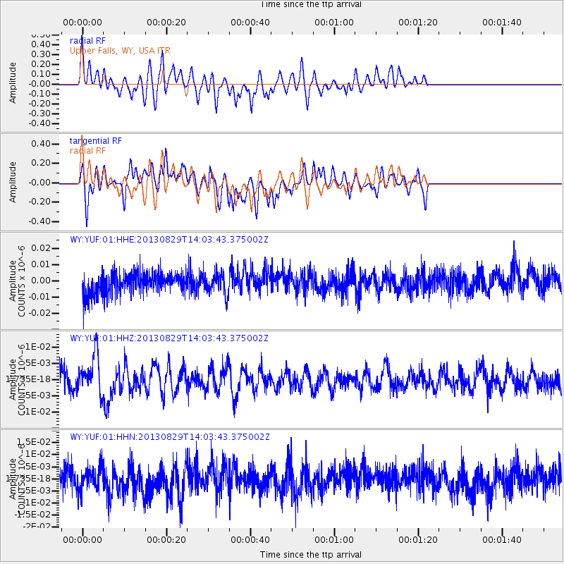
YUF Upper Falls, WY, USA - Earthquake Result Viewer
*The percent match for this event was below the threshold and hence no stack was calculated.
| Earthquake location: |
Fiji Islands Region |
| Earthquake latitude/longitude: |
-19.4/-179.1 |
| Earthquake time(UTC): |
2013/08/29 (241) 13:52:27 GMT |
| Earthquake Depth: |
662 km |
| Earthquake Magnitude: |
5.7 MWW, 5.7 MWW, 5.8 MWC, 5.8 MWB |
| Earthquake Catalog/Contributor: |
NEIC PDE/NEIC COMCAT |
|
| Network: |
WY Yellowstone Wyoming Seismic Network |
| Station: |
YUF Upper Falls, WY, USA |
| Lat/Lon: |
44.71 N/110.51 W |
| Elevation: |
2394 m |
|
| Distance: |
89.2 deg |
| Az: |
41.608 deg |
| Baz: |
241.563 deg |
| Ray Param: |
$rayparam |
*The percent match for this event was below the threshold and hence was not used in the summary stack. |
|
| Radial Match: |
51.587425 % |
| Radial Bump: |
336 |
| Transverse Match: |
56.805164 % |
| Transverse Bump: |
311 |
| SOD ConfigId: |
626651 |
| Insert Time: |
2014-04-18 04:32:36.622 +0000 |
| GWidth: |
2.5 |
| Max Bumps: |
400 |
| Tol: |
0.001 |
|
Signal To Noise
| Channel | StoN | STA | LTA |
| WY:YUF:01:HHZ:20130829T14:03:43.375002Z | 2.0897253 | 6.4701156E-9 | 3.096156E-9 |
| WY:YUF:01:HHN:20130829T14:03:43.375002Z | 0.89953285 | 4.86501E-9 | 5.408374E-9 |
| WY:YUF:01:HHE:20130829T14:03:43.375002Z | 0.9386249 | 6.418067E-9 | 6.8377335E-9 |
| Arrivals |
| Ps | |
| PpPs | |
| PsPs/PpSs | |


