You are here: Home > Network List > US - United States National Seismic Network Stations List
> Station AMTX Amarillo, Texas, USA > Earthquake Result Viewer
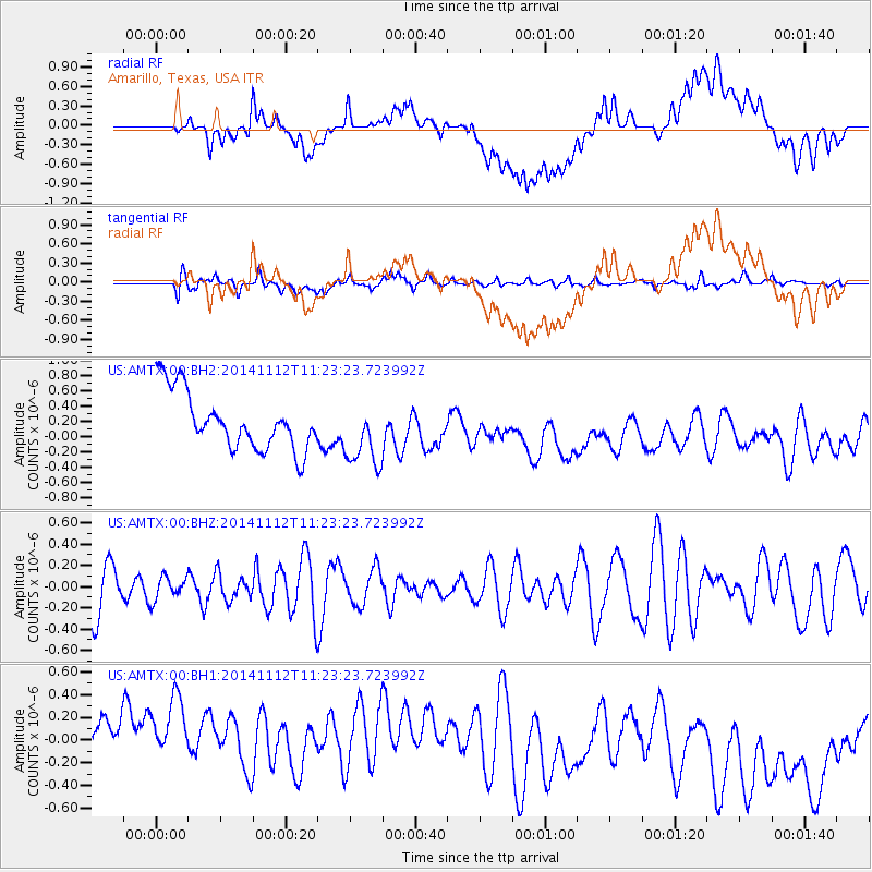
AMTX Amarillo, Texas, USA - Earthquake Result Viewer
*The percent match for this event was below the threshold and hence no stack was calculated.
| Earthquake location: |
Off Coast Of Ecuador |
| Earthquake latitude/longitude: |
1.2/-85.4 |
| Earthquake time(UTC): |
2014/11/12 (316) 11:16:46 GMT |
| Earthquake Depth: |
10 km |
| Earthquake Magnitude: |
5.5 MW, 4.6 mb, 4.8 MS |
| Earthquake Catalog/Contributor: |
ISC/ISC |
|
| Network: |
US United States National Seismic Network |
| Station: |
AMTX Amarillo, Texas, USA |
| Lat/Lon: |
34.53 N/101.41 W |
| Elevation: |
1010 m |
|
| Distance: |
36.4 deg |
| Az: |
337.425 deg |
| Baz: |
152.297 deg |
| Ray Param: |
$rayparam |
*The percent match for this event was below the threshold and hence was not used in the summary stack. |
|
| Radial Match: |
43.445057 % |
| Radial Bump: |
400 |
| Transverse Match: |
52.57104 % |
| Transverse Bump: |
400 |
| SOD ConfigId: |
3390531 |
| Insert Time: |
2019-04-14 23:07:13.118 +0000 |
| GWidth: |
2.5 |
| Max Bumps: |
400 |
| Tol: |
0.001 |
|
Signal To Noise
| Channel | StoN | STA | LTA |
| US:AMTX:00:BHZ:20141112T11:23:23.723992Z | 0.51443166 | 1.0804372E-7 | 2.1002543E-7 |
| US:AMTX:00:BH1:20141112T11:23:23.723992Z | 1.0484607 | 6.828049E-7 | 6.512451E-7 |
| US:AMTX:00:BH2:20141112T11:23:23.723992Z | 1.2121803 | 4.3278314E-7 | 3.5702868E-7 |
| Arrivals |
| Ps | |
| PpPs | |
| PsPs/PpSs | |


