You are here: Home > Network List > GS - US Geological Survey Networks Stations List
> Station KAN10 Keim Farm > Earthquake Result Viewer
KAN10 Keim Farm - Earthquake Result Viewer
*The percent match for this event was below the threshold and hence no stack was calculated.
| Earthquake location: |
Northern Mid-Atlantic Ridge |
| Earthquake latitude/longitude: |
31.6/-40.6 |
| Earthquake time(UTC): |
2014/11/12 (316) 20:05:29 GMT |
| Earthquake Depth: |
10 km |
| Earthquake Magnitude: |
5.0 MW, 4.8 mb, 4.1 MS |
| Earthquake Catalog/Contributor: |
ISC/ISC |
|
| Network: |
GS US Geological Survey Networks |
| Station: |
KAN10 Keim Farm |
| Lat/Lon: |
37.12 N/98.10 W |
| Elevation: |
417 m |
|
| Distance: |
47.1 deg |
| Az: |
293.146 deg |
| Baz: |
78.861 deg |
| Ray Param: |
$rayparam |
*The percent match for this event was below the threshold and hence was not used in the summary stack. |
|
| Radial Match: |
44.396088 % |
| Radial Bump: |
400 |
| Transverse Match: |
49.806644 % |
| Transverse Bump: |
400 |
| SOD ConfigId: |
3390531 |
| Insert Time: |
2019-04-14 23:12:42.322 +0000 |
| GWidth: |
2.5 |
| Max Bumps: |
400 |
| Tol: |
0.001 |
|
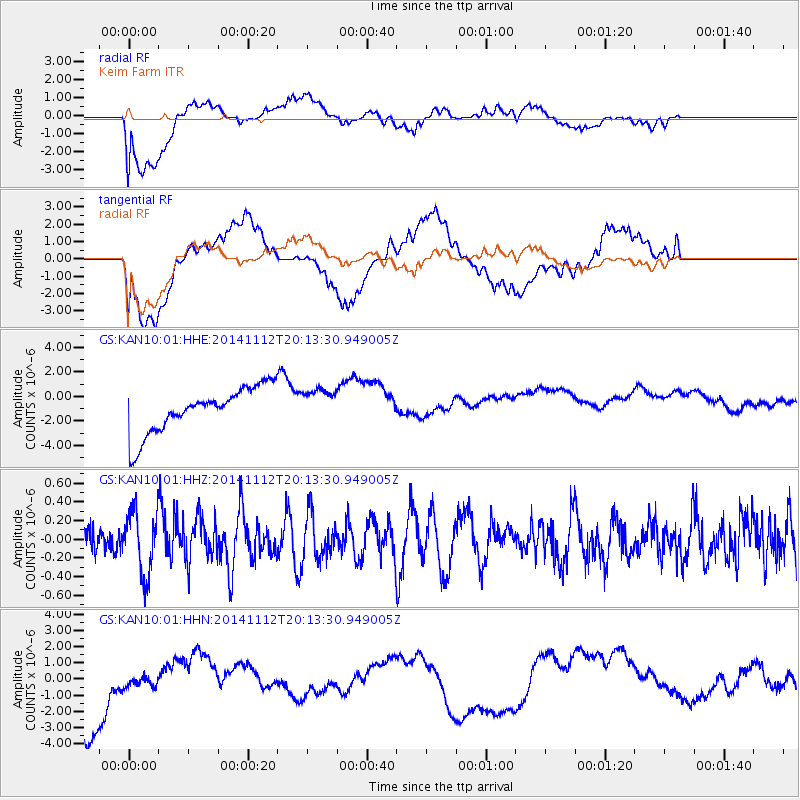
Signal To Noise
| Channel | StoN | STA | LTA |
| GS:KAN10:01:HHZ:20141112T20:13:30.949005Z | 1.1792656 | 3.39298E-7 | 2.8771976E-7 |
| GS:KAN10:01:HHN:20141112T20:13:30.949005Z | 0.28746662 | 9.378729E-7 | 3.2625458E-6 |
| GS:KAN10:01:HHE:20141112T20:13:30.949005Z | 0.75574356 | 1.3956346E-6 | 1.846704E-6 |
| Arrivals |
| Ps | |
| PpPs | |
| PsPs/PpSs | |


