You are here: Home > Network List > TA - USArray Transportable Network (new EarthScope stations) Stations List
> Station R11A Troy Canyon, Currant, NV, USA > Earthquake Result Viewer
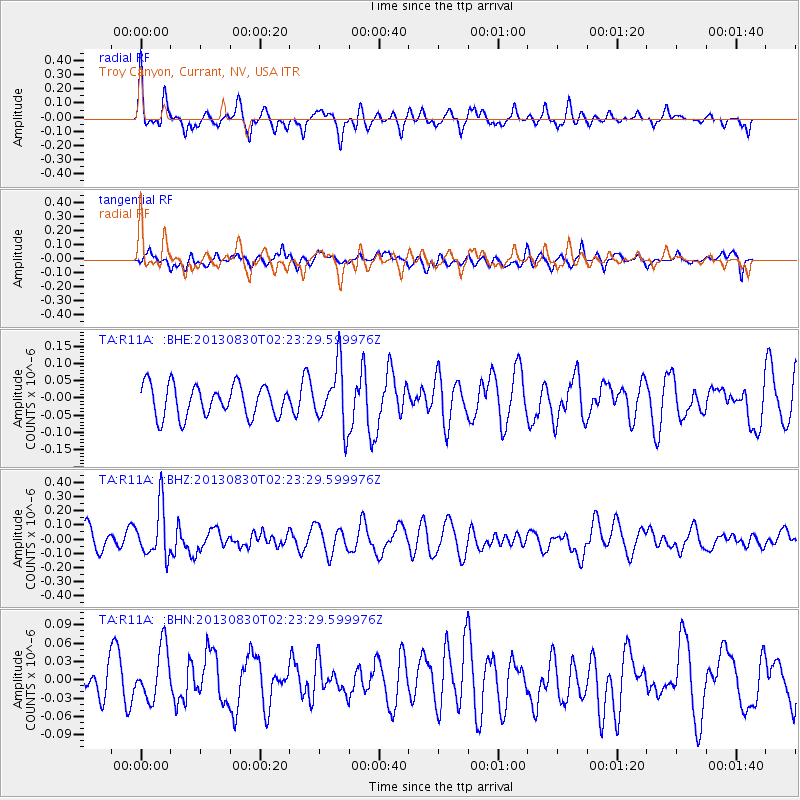
R11A Troy Canyon, Currant, NV, USA - Earthquake Result Viewer
*The percent match for this event was below the threshold and hence no stack was calculated.
| Earthquake location: |
New Britain Region, P.N.G. |
| Earthquake latitude/longitude: |
-4.4/151.6 |
| Earthquake time(UTC): |
2013/08/30 (242) 02:11:02 GMT |
| Earthquake Depth: |
203 km |
| Earthquake Magnitude: |
5.8 MWW, 5.8 MWB, 5.8 MWC, 5.8 MWW, 5.9 MWC |
| Earthquake Catalog/Contributor: |
NEIC PDE/NEIC COMCAT |
|
| Network: |
TA USArray Transportable Network (new EarthScope stations) |
| Station: |
R11A Troy Canyon, Currant, NV, USA |
| Lat/Lon: |
38.35 N/115.59 W |
| Elevation: |
1756 m |
|
| Distance: |
94.9 deg |
| Az: |
52.021 deg |
| Baz: |
268.254 deg |
| Ray Param: |
$rayparam |
*The percent match for this event was below the threshold and hence was not used in the summary stack. |
|
| Radial Match: |
71.45884 % |
| Radial Bump: |
400 |
| Transverse Match: |
51.664795 % |
| Transverse Bump: |
400 |
| SOD ConfigId: |
626651 |
| Insert Time: |
2014-04-18 04:47:20.987 +0000 |
| GWidth: |
2.5 |
| Max Bumps: |
400 |
| Tol: |
0.001 |
|
Signal To Noise
| Channel | StoN | STA | LTA |
| TA:R11A: :BHZ:20130830T02:23:29.599976Z | 2.4175792 | 1.7714216E-7 | 7.327254E-8 |
| TA:R11A: :BHN:20130830T02:23:29.599976Z | 1.1177839 | 4.4109555E-8 | 3.9461614E-8 |
| TA:R11A: :BHE:20130830T02:23:29.599976Z | 1.9028115 | 8.694142E-8 | 4.569103E-8 |
| Arrivals |
| Ps | |
| PpPs | |
| PsPs/PpSs | |


