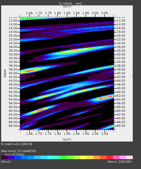
CHRDR Chorukh Dayron, Tajikistan - Earthquake Result Viewer

Earthquake location: New Britain Region, P.N.G.
Earthquake latitude/longitude: -4.4/151.6
Earthquake time(UTC): 2013/08/30 (242) 02:11:02 GMT
Earthquake Depth: 203 km
Earthquake Magnitude: 5.8 MWW, 5.8 MWB, 5.8 MWC, 5.8 MWW, 5.9 MWC
Earthquake Catalog/Contributor: NEIC PDE/NEIC COMCAT
Network: TJ Tajikistan National Seismic Network
Station: CHRDR Chorukh Dayron, Tajikistan
Lat/Lon: 40.39 N/69.67 E
Elevation: 580 m
Distance: 86.7 deg
Az: 310.754 deg
Baz: 98.582 deg
Ray Param: 0.0433667
Estimated Moho Depth: 52.75 km
Estimated Crust Vp/Vs: 2.05
Assumed Crust Vp: 6.316 km/s
Estimated Crust Vs: 3.085 km/s
Estimated Crust Poisson's Ratio: 0.34
Radial Match: 82.169106 %
Radial Bump: 400
Transverse Match: 81.32672 %
Transverse Bump: 400
SOD ConfigId: 626651
Insert Time: 2014-04-18 04:47:29.164 +0000
GWidth: 2.5
Max Bumps: 400
Tol: 0.001

Signal To Noise

ChannelStoNSTALTA
TJ:CHRDR: :HHZ:20130830T02:22:51.640015Z7.20037569.828606E-71.365013E-7
TJ:CHRDR: :HHN:20130830T02:22:51.640015Z0.876086532.0643205E-92.3562976E-9
TJ:CHRDR: :HHE:20130830T02:22:51.640015Z1.3783742.5376798E-71.8410677E-7
Arrivals
Ps8.9 SECOND
PpPs25 SECOND
PsPs/PpSs34 SECOND