You are here: Home > Network List > US - United States National Seismic Network Stations List
> Station LKWY Lake (Yellowstone--Lake), Wyoming, USA > Earthquake Result Viewer
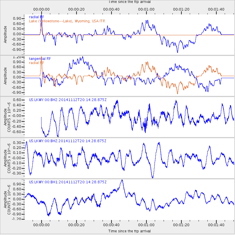
LKWY Lake (Yellowstone--Lake), Wyoming, USA - Earthquake Result Viewer
*The percent match for this event was below the threshold and hence no stack was calculated.
| Earthquake location: |
Northern Mid-Atlantic Ridge |
| Earthquake latitude/longitude: |
31.6/-40.6 |
| Earthquake time(UTC): |
2014/11/12 (316) 20:05:29 GMT |
| Earthquake Depth: |
10 km |
| Earthquake Magnitude: |
5.0 MW, 4.8 mb, 4.1 MS |
| Earthquake Catalog/Contributor: |
ISC/ISC |
|
| Network: |
US United States National Seismic Network |
| Station: |
LKWY Lake (Yellowstone--Lake), Wyoming, USA |
| Lat/Lon: |
44.57 N/110.40 W |
| Elevation: |
2424 m |
|
| Distance: |
54.8 deg |
| Az: |
304.868 deg |
| Baz: |
78.223 deg |
| Ray Param: |
$rayparam |
*The percent match for this event was below the threshold and hence was not used in the summary stack. |
|
| Radial Match: |
45.239735 % |
| Radial Bump: |
400 |
| Transverse Match: |
38.84845 % |
| Transverse Bump: |
400 |
| SOD ConfigId: |
3390531 |
| Insert Time: |
2019-04-14 23:16:13.506 +0000 |
| GWidth: |
2.5 |
| Max Bumps: |
400 |
| Tol: |
0.001 |
|
Signal To Noise
| Channel | StoN | STA | LTA |
| US:LKWY:00:BHZ:20141112T20:14:28.875Z | 0.41154686 | 7.8957484E-8 | 1.918554E-7 |
| US:LKWY:00:BH1:20141112T20:14:28.875Z | 1.5080929 | 6.7900504E-7 | 4.5024086E-7 |
| US:LKWY:00:BH2:20141112T20:14:28.875Z | 1.165 | 4.060937E-7 | 3.4857828E-7 |
| Arrivals |
| Ps | |
| PpPs | |
| PsPs/PpSs | |


