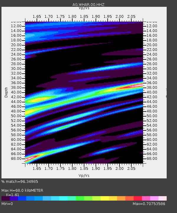
WHAR Woolly Hollow State Park,AR - Earthquake Result Viewer

Earthquake location: Andreanof Islands, Aleutian Is.
Earthquake latitude/longitude: 51.5/-175.2
Earthquake time(UTC): 2013/08/30 (242) 16:25:02 GMT
Earthquake Depth: 29 km
Earthquake Magnitude: 7.0 MWW, 6.5 ML, 6.8 MI, 6.9 MWC, 6.9 MWB, 7.0 MWW, 7.0 MI, 7.0 MWC
Earthquake Catalog/Contributor: NEIC PDE/NEIC COMCAT
Network: AG Arkansas Seismic Network
Station: WHAR Woolly Hollow State Park,AR
Lat/Lon: 35.29 N/92.29 W
Elevation: 184 m
Distance: 59.2 deg
Az: 70.928 deg
Baz: 313.816 deg
Ray Param: 0.062294777
Estimated Moho Depth: 68.0 km
Estimated Crust Vp/Vs: 1.61
Assumed Crust Vp: 6.498 km/s
Estimated Crust Vs: 4.036 km/s
Estimated Crust Poisson's Ratio: 0.19
Radial Match: 96.34985 %
Radial Bump: 308
Transverse Match: 86.9389 %
Transverse Bump: 400
SOD ConfigId: 626651
Insert Time: 2014-04-18 04:50:53.280 +0000
GWidth: 2.5
Max Bumps: 400
Tol: 0.001

Signal To Noise

ChannelStoNSTALTA
AG:WHAR:00:HHZ:20130830T16:34:29.834973Z18.4978891.8363428E-69.927311E-8
AG:WHAR:00:HHN:20130830T16:34:29.834973Z7.8995347.5960975E-79.61588E-8
AG:WHAR:00:HHE:20130830T16:34:29.834973Z5.2713046.761066E-71.2826173E-7
Arrivals
Ps6.7 SECOND
PpPs26 SECOND
PsPs/PpSs33 SECOND