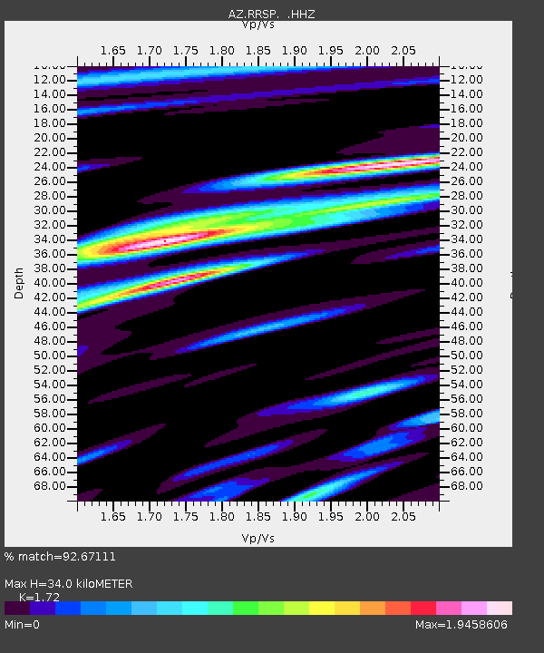
RRSP RRSP, CA, USA - Earthquake Result Viewer

Earthquake location: Andreanof Islands, Aleutian Is.
Earthquake latitude/longitude: 51.5/-175.2
Earthquake time(UTC): 2013/08/30 (242) 16:25:02 GMT
Earthquake Depth: 29 km
Earthquake Magnitude: 7.0 MWW, 6.5 ML, 6.8 MI, 6.9 MWC, 6.9 MWB, 7.0 MWW, 7.0 MI, 7.0 MWC
Earthquake Catalog/Contributor: NEIC PDE/NEIC COMCAT
Network: AZ ANZA Regional Network
Station: RRSP RRSP, CA, USA
Lat/Lon: 33.65 N/116.74 W
Elevation: 1610 m
Distance: 45.3 deg
Az: 89.676 deg
Baz: 311.518 deg
Ray Param: 0.071294874
Estimated Moho Depth: 34.0 km
Estimated Crust Vp/Vs: 1.72
Assumed Crust Vp: 6.264 km/s
Estimated Crust Vs: 3.642 km/s
Estimated Crust Poisson's Ratio: 0.24
Radial Match: 92.67111 %
Radial Bump: 400
Transverse Match: 85.70962 %
Transverse Bump: 400
SOD ConfigId: 626651
Insert Time: 2014-04-18 04:52:43.193 +0000
GWidth: 2.5
Max Bumps: 400
Tol: 0.001

Signal To Noise

ChannelStoNSTALTA
AZ:RRSP: :HHZ:20130830T16:32:47.009015Z5.5639016.663163E-71.1975703E-7
AZ:RRSP: :HHN:20130830T16:32:47.009015Z2.04553533.0135797E-71.4732473E-7
AZ:RRSP: :HHE:20130830T16:32:47.009015Z2.64383753.5010385E-71.324226E-7
Arrivals
Ps4.2 SECOND
PpPs14 SECOND
PsPs/PpSs18 SECOND