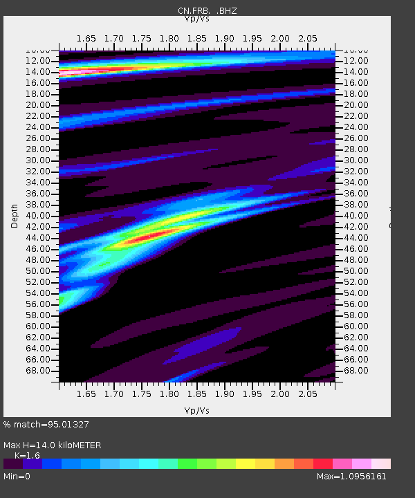
FRB IQALUIT, N.W.T. - Earthquake Result Viewer

Earthquake location: Andreanof Islands, Aleutian Is.
Earthquake latitude/longitude: 51.5/-175.2
Earthquake time(UTC): 2013/08/30 (242) 16:25:02 GMT
Earthquake Depth: 29 km
Earthquake Magnitude: 7.0 MWW, 6.5 ML, 6.8 MI, 6.9 MWC, 6.9 MWB, 7.0 MWW, 7.0 MI, 7.0 MWC
Earthquake Catalog/Contributor: NEIC PDE/NEIC COMCAT
Network: CN Canadian National Seismograph Network
Station: FRB IQALUIT, N.W.T.
Lat/Lon: 63.75 N/68.55 W
Elevation: 18 m
Distance: 51.7 deg
Az: 32.876 deg
Baz: 310.33 deg
Ray Param: 0.06718895
Estimated Moho Depth: 14.0 km
Estimated Crust Vp/Vs: 1.60
Assumed Crust Vp: 6.419 km/s
Estimated Crust Vs: 4.012 km/s
Estimated Crust Poisson's Ratio: 0.18
Radial Match: 95.01327 %
Radial Bump: 400
Transverse Match: 62.00127 %
Transverse Bump: 400
SOD ConfigId: 626651
Insert Time: 2014-04-18 04:56:21.369 +0000
GWidth: 2.5
Max Bumps: 400
Tol: 0.001

Signal To Noise

ChannelStoNSTALTA
CN:FRB: :BHZ:20130830T16:33:35.974988Z7.40756032.7428025E-63.702707E-7
CN:FRB: :BHN:20130830T16:33:35.974988Z5.11132861.1223369E-62.195783E-7
CN:FRB: :BHE:20130830T16:33:35.974988Z4.55093341.2218727E-62.6848838E-7
Arrivals
Ps1.4 SECOND
PpPs5.3 SECOND
PsPs/PpSs6.7 SECOND